Wimpole Way Walk with OS Map
![]()
![]() Follow the Wimpole way through Cambridgeshire's farmland, ancient woodland and gentle rolling countryside from Cambridge to Wimpole Hall. The path starts in Cambridge by the River Cam heading ino the countryside and passing Coton, Caldecote and Kingston before finishing at Wimpole Hall. This 17th century country house has 3,000Āacres of parkland and farmland and is owned by the National Trust. Also on the path is Hardwick Wood near Caldecote.
Follow the Wimpole way through Cambridgeshire's farmland, ancient woodland and gentle rolling countryside from Cambridge to Wimpole Hall. The path starts in Cambridge by the River Cam heading ino the countryside and passing Coton, Caldecote and Kingston before finishing at Wimpole Hall. This 17th century country house has 3,000Āacres of parkland and farmland and is owned by the National Trust. Also on the path is Hardwick Wood near Caldecote.
The nature reserve includes woodland trails and some nice flora and fauna to look out for.
Wimpole Way Ordnance Survey Map  - view and print off detailed OS map
Wimpole Way Open Street Map  - view and print off detailed map
*New* - Walks and Cycle Routes Near Me Map - Waymarked Routes and Mountain Bike Trails>>
Wimpole Way OS Map  - Mobile GPS OS Map with Location tracking
Wimpole Way Open Street Map  - Mobile GPS Map with Location tracking
Further Information and Other Local Ideas
For some more interesting local history head to the nearby Madingley Hall. Here you will find some beautiful ‘Capability’ Brown landscaped gardens surrounding a fine 16th century manor house.
Cycle Routes and Walking Routes Nearby
Photos

Wimpole Way near Kingston Evening is drawing on and the ripening rape field casts deep shadows across the path.

Wooded Wimpole Way
.jpg)
Wimpole Hall 1

Wimpole Hall 2

ĀWimpole Way near Kingston I'm using the name on the signposts rather than the one on the map. The map is right in that there is another broad path on the other side of the hedge.

Wheat field beside Wimpole Way
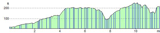
Elevation Profile