World's End Llangollen
![]()
![]() Explore this beautiful narrow vale on this popular circular walk near Llangollen.
Explore this beautiful narrow vale on this popular circular walk near Llangollen.
The World's End Gorge is a great place for a walk with pretty streams, little waterfalls and attractive woodland. It's an atmospheric place with the area enclosed by the cliffs of Craig y Forwyn, Craig y Cythraul, and Craig yr Adar.
The walk takes you through the delightful wooded gorge to the heather moors on top of the Eglwyseg Mountain. As such it's a nice varied route with wonderful views of the River Eglwyseg and the surrounding Welsh Hills with lots of interesting flora and fauna. You can start off from the public car parking area just off a country lane to the north of the site.
This route is designed for walkers but the area is also popular with mountain bikers. See the video below of cyclists on the Horseshoe Pass for details!
The Offa's Dyke Path runs past the area so you could pick this up and head north to the nearby Llandegla Forest.
If you would like a more challenging walk then try the climb to Castell Dinas Bran. The atmospheric ruins of the medieval castle are a must see if you are visiting the area.
Easier walking can be found along the towpath of the lovely Llangollen Canal.
You could also start the walk from Llangollen and follow the trail through the beautiful Vale of Llangollen to World's End. Our Panorama Walk starts from the nearby famous Pontcysyllte Aqueduct and follows the scenic country road up to the site. The area is also only a few miles west of Wrexham.
Postcode
LL20 8EH - Please note: Postcode may be approximate for some rural locationsWorld's End Llangollen Ordnance Survey Map  - view and print off detailed OS map
World's End Llangollen Open Street Map  - view and print off detailed map
World's End Llangollen OS Map  - Mobile GPS OS Map with Location tracking
World's End Llangollen Open Street Map  - Mobile GPS Map with Location tracking
Pubs/Cafes
Just to the west you'll find the Ponderosa Cafe on the Horseshoe Pass. The large cafe serves a good range of meals and snacks. There's a splendid outdoor seating area with excellent views over the surrounding hills. At 1,400 ft above sea level you can see the Clwydian Mountain range and on a very clear day the three peaks of Snowdon. There's also Bed & Breakfast Accommodation, a gift shop and a large car park at the extensive complex. Postcode is LL20 8DR.
The circular Horseshoe Pass Walk also starts from the cafe. The trail visits Cyrn-y-Brain mountain, Llandegla Forest, World's End, Craig Arthur and the Eglwyseg River valley.
Further Information and Other Local Ideas
Just to the north east there's the Minera Lead Mines and Quarry. Here you can learn all about the fascinating industrial past of the area at the mining museum.
Cycle Routes and Walking Routes Nearby
Photos
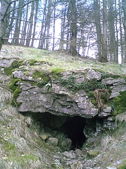
Spring/ Water Up-welling. This is the point close to the path where the water that is travelling through the World's End limestone cave system wells up. If you follow the path a hundred metres or so uphill to a cave you can clearly hear the water flowing down to this spring. Although it is on a much smaller scale this is reminiscent of the way Malham Beck bubbles from the base of Malham Cove.
Plas Uchaf, Worlds End. A much improved house with an attached farm going for full organic status. Plas Uchaf, an Elizabethan half-timbered manor house, dating from 1563, which was built on the site of the 12th century hunting lodge of Owain ap Cadwgan. Another occupant was Colonel John Jones, who was the brother-in-law of Oliver Cromwell, and one of the signatories of Charles I's death warrant. There is also a local rumour that Elizabeth I came here to give birth to an illegitimate child.


