Greenwich to Croydon
15.5 miles (25 km)
![]()
![]() This ride follows National Cycle Route 21, taking you through south east London. The ride starts by the Cutty Sark on the Thames in Greenwich and heads south along the Ravensbourne River and Pool River to New Beckenham. From there you continue south to Elmers End where you will pass through the lovely South Norwood Country Park.
This ride follows National Cycle Route 21, taking you through south east London. The ride starts by the Cutty Sark on the Thames in Greenwich and heads south along the Ravensbourne River and Pool River to New Beckenham. From there you continue south to Elmers End where you will pass through the lovely South Norwood Country Park.
You then pass through Addington golf course and the Addington Hills along the London Loop taking you to the finish point at South Croydon rail.
Greenwich to Croydon Ordnance Survey Map  - view and print off detailed OS map
Greenwich to Croydon Open Street Map  - view and print off detailed map
Greenwich to Croydon OS Map  - Mobile GPS OS Map with Location tracking
Greenwich to Croydon Open Street Map  - Mobile GPS Map with Location tracking
Cycle Routes and Walking Routes Nearby
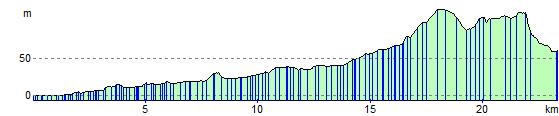
Elevation Profile