Arden Way
![]()
![]() This circular walk takes you on a tour of the beautiful Forest of Arden in Warwickshire. The route starts and ends near Henley in Arden railway, first taking you to Ulenhall before heading towards Studley where you will pass the impressive 19th century Studley Castle which is now a luxury hotel. You then join the River Arrow leading you to Coughton. Here you will find the 16th century Tudor house Coughton Court which has a place in English history for its role in the Gunpowder Plot of 1605 as some of the conspirators rode directly back there after it failed.
This circular walk takes you on a tour of the beautiful Forest of Arden in Warwickshire. The route starts and ends near Henley in Arden railway, first taking you to Ulenhall before heading towards Studley where you will pass the impressive 19th century Studley Castle which is now a luxury hotel. You then join the River Arrow leading you to Coughton. Here you will find the 16th century Tudor house Coughton Court which has a place in English history for its role in the Gunpowder Plot of 1605 as some of the conspirators rode directly back there after it failed.
From Coughton you head to the attractive market town of Alcester, then through Oversley Wood to Exhall where you turn north. The walk then passes Spernall Park and Bannan's wood before returning to Henley-in-Arden.
Arden Way Ordnance Survey Map  - view and print off detailed OS map
Arden Way Open Street Map  - view and print off detailed map
Arden Way OS Map  - Mobile GPS OS Map with Location tracking
Arden Way Open Street Map  - Mobile GPS Map with Location tracking
Pubs/Cafes
In Alcester head to the excellent The Moat House Inn for some refreshments on the route. The pub has a lovely large garden area where you can even hire a teepee. It's a lovely place to relax on a warm summer day. The menu is also very good and there's nice cosy fires indoors for colder days. You can find the pub on Birmingham Rd with a postcode of B49 5QF for sat navs.
Cycle Routes and Walking Routes Nearby
Photos

Arden Way towards New End Farm. Tree-lined banks to this lane with a lot of bluebells.

Ploughed field south of the Arden Way

Windmill Hill.
.jpg)
Coughton Ford. This ford is found on the River Arrow. The Arden Way crosses the river at this point and also forms part of the National Cycle Network. The Roman road, Ryknild Street, runs close by to the west.

Track to New End Farm. Peaceful section of the trail.

Site of Henley Junction. The train is just passing the site of the junction of the old line to Rowington Junction, seen from the trail.

Henkey signal box. The signal box and one of the remaining semaphore signals, seen from the trail.

Lower Spernall Farm. View from the footpath across the meadow beside the River Arrow.
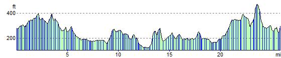
Elevation Profile