Loughrigg Fell Walk
![]()
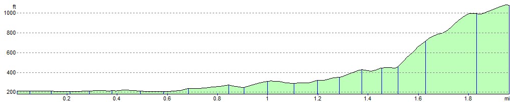
![]() The climb to Loughrigg fell from Grasmere is a very popular one. It's a reasonably straightforward climb with wonderful views over Rydal Water and Grasmere Lake. The walk starts in the centre of Grasmere and follows country lanes and good footpaths to the 335 m (1,099 ft) summit. You start by following Red Bank road from Grasmere which runs around the western side of the lake before picking up a footpath to the summit which is effectivley a series of stone steps. The route also passes Loughrigg Terrace which is well worth a short detour. This level path affords wonderful views towards Helm Crag and the Fairfield group and leads to the fascinating Loughrigg Caves.
The climb to Loughrigg fell from Grasmere is a very popular one. It's a reasonably straightforward climb with wonderful views over Rydal Water and Grasmere Lake. The walk starts in the centre of Grasmere and follows country lanes and good footpaths to the 335 m (1,099 ft) summit. You start by following Red Bank road from Grasmere which runs around the western side of the lake before picking up a footpath to the summit which is effectivley a series of stone steps. The route also passes Loughrigg Terrace which is well worth a short detour. This level path affords wonderful views towards Helm Crag and the Fairfield group and leads to the fascinating Loughrigg Caves.
From the Loughrigg Fell summit there are lovely views of Elterwater, Langdale, the Coniston Fells and Windermere. You will also find an Ordnance Survey triangulation column beside a large cairn.
The fell is on the Windermere Way circular walk, so you can pick this up to extend your walk.
You could also descend the hill to the south and visit the tranquil Loughrigg Tarn and continue to Elterwater where you can enjoy a waterside stroll along the River Brathay and visit Skelwith Force waterfall.
Loughrigg Fell Ordnance Survey Map  - view and print off detailed OS map
Loughrigg Fell Open Street Map  - view and print off detailed map
Loughrigg Fell OS Map  - Mobile GPS OS Map with Location tracking
Loughrigg Fell Open Street Map  - Mobile GPS Map with Location tracking
Further Information and Other Local Ideas
Just to the north there's the climb to Silver How from Grasmere. The walk also visits the National Trust owned Allan Bank, the former home of William Wordsworth.
For more walking ideas in the area see the Lake District Walks page.
Cycle Routes and Walking Routes Nearby
Photos

Grasmere from Loughrigg Fell

Cairn on Loughrigg Fell

The fell From the path to The How. Junipers on Lad Crag in shot

Path descending off the fell. This footpath is somewhat juicy, having been adopted by a small stream as the best way of descending towards the River Rothay in the valley below. We were walking between Loughrigg Tarn and Rydal.

Ewe Crag on the north edge of Loughrigg Fell. This is the view southwest from the bridle path between Rydal Water and Grasmere

Looking into Langdale from the fell.

A couple relax on the summit.

Small Tarn on the fell.
Elevation Profile