Nine Standards Rigg
![]()
![]() Enjoy wonderful views over the Eden Valley on this climb to the summit of Hartley Fell in the North Pennines AONB. The walk starts from Kirkby Stephen and climbs to the 662 m (2,172 ft) summit on a mixture of country lanes and footpaths. You will pass a series of cairns about 10ft tall known as the Nine Standards. At the summit there is a trig point that marks the watershed divide across England. From here, rivers flow west toward the Irish Sea and east toward the North Sea. There are also wonderful views of Cross Fell, Great Dun Fell and the Howgills.
Enjoy wonderful views over the Eden Valley on this climb to the summit of Hartley Fell in the North Pennines AONB. The walk starts from Kirkby Stephen and climbs to the 662 m (2,172 ft) summit on a mixture of country lanes and footpaths. You will pass a series of cairns about 10ft tall known as the Nine Standards. At the summit there is a trig point that marks the watershed divide across England. From here, rivers flow west toward the Irish Sea and east toward the North Sea. There are also wonderful views of Cross Fell, Great Dun Fell and the Howgills.
The walk is on Wainwright's Coast to Coast walking route so you could pick this up to continue your walking in the area.
To continue your walking in the area you can try our Kirkby Stephen Circular Walk and enjoy riverside paths along the River Eden.
Nine Standards Rigg Ordnance Survey Map  - view and print off detailed OS map
Nine Standards Rigg Open Street Map  - view and print off detailed map
Nine Standards Rigg OS Map  - Mobile GPS OS Map with Location tracking
Nine Standards Rigg Open Street Map  - Mobile GPS Map with Location tracking
Further Information and Other Local Ideas
Near the site there's the interesting town of Brough. Here you'll find the historic ruins of the 11th century Brough Castle and some nice trails along the Swindale Beck.
For more walking ideas in the area see the North Pennines Walks page.
Cycle Routes and Walking Routes Nearby
Photos

The Nine Standards, Cumbria. The origin of these carefully constructed dry-stone cairns is unknown but they have stood on this wild site for many hundreds of years.

The four most northerly cairns on Nine Standards Rigg have been very neatly rebuilt.

Topograph at the summit. This handy topograph details all the sights you can view from this excellent viewpoint

The pimple on the horizon is the viewfinder pillar which can be confused for the trig pillar in mist. On the approach over Baxton Gill Head the Standards remain out of sight until the last moment.

Above Rollinson Gill looking over Dukerdale and Nateby Common.

Long Rigg is an attractive little limestone scar that makes an interesting alternative approach to the main Nine Standards Rigg track. The farm at Cote Garth can just be seen to the left of the scar with the Eden valley beyond.
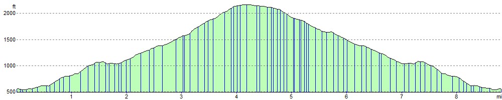
Elevation Profile