Pap of Glencoe Walk Map
![]()
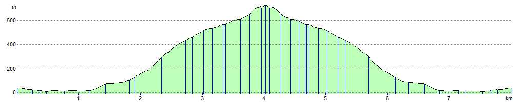
![]() This challenging walk takes you up the 742 m (2,434 ft) high Pap of Glencoe in the Highlands of Scotland. The walk begins at the car park at Lochan to the east of the village of Glencoe. It starts by passing through woodland before beginning the climb along the mountain tracks. It is a steep climb with some muddy sections and some scrambling for the last 100 metres to the summit. However, you will be rewarded with breathtaking views over Glencoe, the Mamores and Loch Leven.
This challenging walk takes you up the 742 m (2,434 ft) high Pap of Glencoe in the Highlands of Scotland. The walk begins at the car park at Lochan to the east of the village of Glencoe. It starts by passing through woodland before beginning the climb along the mountain tracks. It is a steep climb with some muddy sections and some scrambling for the last 100 metres to the summit. However, you will be rewarded with breathtaking views over Glencoe, the Mamores and Loch Leven.
If you are looking for a more gentle walk in the area then you could try the Glencoe Lochan Trail which starts from the same car park.
Pap of Glencoe Ordnance Survey Map  - view and print off detailed OS map
Pap of Glencoe Open Street Map  - view and print off detailed map
*New* - Walks and Cycle Routes Near Me Map - Waymarked Routes and Mountain Bike Trails>>
Pap of Glencoe OS Map  - Mobile GPS OS Map with Location tracking
Pap of Glencoe Open Street Map  - Mobile GPS Map with Location tracking
Pubs/Cafes
If you head into the village you could pay a visit to the splendid Glencoe Cafe. They serve a good range of meals and snacks. There's also a gift shop selling gifts, books and maps. You can find them at postcode PH49 4HP for your sat navs.
Further Information and Other Local Ideas
The wonderful Buachaille Etive Mor is located a few miles to the south east and well worth a visit.
Further to the east is the remote Corrour Station. The station is notable as the highest mainline railway station in the United Kingdom. From here there is a nice trail to follow to the nearby Loch Ossian. Loch Treig can also be visited in this area.
Head north and you could visit the second highest waterfall in Scotland on the Steall Falls Walk. It's a spectacular sight and another scenic highlight of the area.
A few miles to the east you'll find the Three Sisters Glencoe Waterfall Walk. There's a car park and viewpoint here with excellent views of the three striking mountains. You can then pick up trails along the River Coe with a series of pretty waterfalls to see on the way.
Head south west and there's the popular coastal town of Oban to visit. There's a lovely bay and a fine climb to the viewpoint on McCaig's Tower to enjoy here. To the north of the town there's the expansive Loch Creran where you can visit the wildlife rich Shian Woodland Nature Reserve.
For more walking ideas in the area see the Scottish Highlands Walks page.
Cycle Routes and Walking Routes Nearby
Photos

Summit of the Pap of Glencoe. Picture taken from the summit looking west out of Loch Leven. Visibility wasn't the best hence the slight haze

Slopes of Sgorr na Ciche

West across Loch Leven; Eilean Munde is the largest islet. Garbh Bheinn in Ardgour (2903ft) is visible across Loch Linnhe.

Towards the Pap of Glencoe over Loch Leven from the West Highland Way.

Summit, Sgorr na Ciche

Walking down from the Pap

View down Loch Leven. Picture taken from quarter of the way up the Pap looking out West towards the Ballchulish Bridge

Pap of Glencoe from Isles of Glencoe Hotel. Panoramic view from the hotel on a beautiful May day in 2006. The Pap is the particularly abrupt peak towards the right of the picture. Weather changeable, views always breathtaking.
Elevation Profile