Pen y ghent Walk
![]()
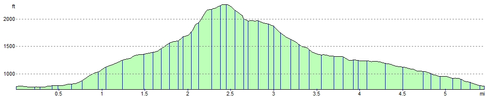
![]() Climb to the 694 m (2,277 ft) summit of Pen y ghent on this challenging circular walk in the Yorkshire Dales. Pen y ghent is probably the most famous and popular of the Yorkshire Three Peaks. The others are Ingleborough and Whernside. This route is the classic ascent from Horton in Ribblesdale via Brackenbottom Scar. It runs for just under 6 miles and includes a challenging ascent of over 1300ft.
Climb to the 694 m (2,277 ft) summit of Pen y ghent on this challenging circular walk in the Yorkshire Dales. Pen y ghent is probably the most famous and popular of the Yorkshire Three Peaks. The others are Ingleborough and Whernside. This route is the classic ascent from Horton in Ribblesdale via Brackenbottom Scar. It runs for just under 6 miles and includes a challenging ascent of over 1300ft.
You start in the village of Horton in Ribblesdale at the car park and follow country lanes towards Brackenbottom. You continue the ascent, picking up the Pennine Way just before reaching the summit. From here there are fabulous views across the Yorkshire Dales. The descent follows the Pennine Way passing Tarn Barn, Horton Scar and Hull Point - the largest natural hole in England.
The mountain is located close to the Malham Tarn Estate where you can enjoying cycling and walking trails around the beautiful glacial lake and try another challenging climb to Fountains Fell and Fountains Fell Tarn.
Pen y ghent Ordnance Survey Map  - view and print off detailed OS map
Pen y ghent Open Street Map  - view and print off detailed map
Pen y ghent OS Map  - Mobile GPS OS Map with Location tracking
Pen y ghent Open Street Map  - Mobile GPS Map with Location tracking
Pubs/Cafes
In Horton in Ribblesdale head to the Helwith Bridge Inn for some well earned refreshments after your walk. The friendly pub has a great menu, a good selection of beers and outdoor seating. Here you can sit next to the River Ribble and enjoy fine views towards the hills if the weather is fine. You can find it on Austwick Rd with a postcode of BD24 0EH for your sat navs.
Dog Walking
Fit dogs will enjoy the climb to the hill summit so you'll probably see other owners with their pets on your visit. There is some livestock around so it's probably best to put them on leads in these areas. The Helwith Bridge Inn mentioned above is also dog friendly.
Further Information and Other Local Ideas
For a shorter route you could try the Hull Pot Walk which visits the wonderful natural hole on the slopes of the mountain. Here you'll find England's largest naturally formed hole measuring 91 metres (300 feet) long by 18 metres (60 feet) wide by 18 metres (60 feet) deep. The waterfall that flows into it from the Hull Pot Beck is a spectacular sight after rainfall. It's located just off the Pennine Way about 1.6 miles north east of Horton.
The waymarked Ribble Way passes through Horton. You could pick up the riverside trails and follow it south to Helwith Bridge and Stainforth where you can visit the lovely Stainforth Force Waterfall.
The village of Horton is accessible by rail on the Settle–Carlisle Line. There is about one train every two hours in each direction: southbound to Leeds (seven in total) and northbound to Carlisle (eight, plus one evening train that terminates at Ribblehead).
Cycle Routes and Walking Routes Nearby
Photos

Limestone cliffs to the north of Pen-y-ghent summit.

Stiles, walls, and Pen y Ghent. Looking along a moorland path towards the hill. The footpath follows the stone wall which is also the parish boundary between Horton in Ribblesdale on the left and Stainforth on the right.

Plover Hill and Pen y ghent. Seen here during a slight temperature inversion from Little Ingleborough with Fell Beck in the foreground

Pen Y Ghent summit. Looking towards one of the other 3 peaks Ingleborough.

Hull Pot. Hull Pot Beck is practically dry even after a very rainy couple of days unlike its subterranean counterpart on the right hand side of the pot

Helwith Bridge and Inn. A fine choice for refreshments in Horton in Ribblesdale. Looking west across Helwith Bridge with the Helwith Bridge Inn on the right alongside the River Ribble. Dry Rigg Quarry is in the background.
Elevation Profile