Yorkshire Three Peaks
![]()
![]() Visit the famous Yorkshire Dales three peaks of Pen y ghent, Whernside and Ingleborough on this challenging circular walk.
Visit the famous Yorkshire Dales three peaks of Pen y ghent, Whernside and Ingleborough on this challenging circular walk.
The three peaks challenge is a popular walk with those raising money for charities. You can also join an organised group walk, see the link below for more details.
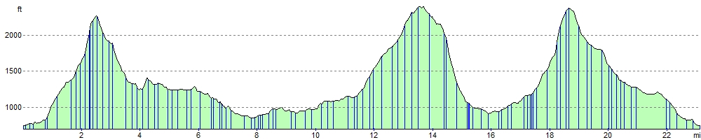
The route begins in Horton in Ribblesdale and heads first to Pen y ghent. The footpath climbs to the 694 m (2,277 ft) summit via Brackenbottom Scar, before descending on the Pennine Way via Tarn Barn, Horton Scar, Jackdaw Hill and Hull Point - the largest natural hole in England.
The walk then continues to Whernside, passing caves, becks and waterfalls on your way to Ribblehead. You then ascend to the 736 m (2,415 ft) Whernside summit via Ribblehead Viaduct, the Blue Clay Ridge, Little Dale Beck and Force Gill where you can see a series of waterfalls. You descend via Broadrake, Philpin Lane and Low Hill.
You then begin the ascent of Ingleborough, passing through the lovely Ingleborough Nature Reserve on your way to the 723 metres (2,372 ft) summit. The route descends back to the finish point at Horton in Ribblesdale via Simon Fell, Grouse Butts and Sulber.
Many people aim to complete the challenge in under 12 hours. Those that do are invited to pay to join the Pen-y-ghent Cafe's privately owned 'Three Peaks of Yorkshire Club'.
Please click here for more information
Yorkshire Three Peaks Ordnance Survey Map  - view and print off detailed OS map
Yorkshire Three Peaks Open Street Map  - view and print off detailed map
Yorkshire Three Peaks OS Map  - Mobile GPS OS Map with Location tracking
Yorkshire Three Peaks Open Street Map  - Mobile GPS Map with Location tracking
Pubs/Cafes
In Horton in Ribblesdale head to the Helwith Bridge Inn for some well earned refreshments after your walk. The friendly pub has a great menu, a good selection of beers and outdoor seating.
There's also the Station Inn at Ribblehead (Postcode: LA6 3AS). The pub is located next to the Ribblehead Viaduct and is very walker friendly. There's a good menu and you can also book rooms for the night. Just up the road to the west you'll find the Old Hill Inn (LA6 3AR). This pub dates all the way back to 1615 and is another popular spot for hungry walkers after climbing the peaks.
Cycle Routes and Walking Routes Nearby
Photos

Pen-y-ghent. The path from Brackenbottom.

Pen-y-ghent summit

Whernside.

Ridge Path on Whernside

Ingleborough. Taken from the limestone across the valley on a cold Spring day.

Ingleborough

The Summit of Ingleborough. Taken at the one moment there was only one figure. There were at least fifty people on the summit walking of the excesses of Xmas

Yorkshire Three Peaks from Bleaklow, Peak District. Taken from near the Wainstones on Bleaklow in the Peak District on a remarkably clear day. Ingleborough (SD7474) is to the far left, Whernside (SD7381) is there but less obvious to the right of Ingleborough, and Pen-y-Ghent is plainly visible to the far right of the picture. Whernside is actually the furthest (58 miles), but Bleaklow to Pen-y-ghent is a still-impressive 51 miles.
Elevation Profile