St Oswald's Way Walk with OS Map and GPX
![]()
![]() Explore the coastline, islands, river valleys, hills, villages, forests and farmland of Northumberland and follow in the footstepts of St. Oswald - the King of Northumbria in the early 7th Century, who played a major part in bringing Christianity to the region.
Explore the coastline, islands, river valleys, hills, villages, forests and farmland of Northumberland and follow in the footstepts of St. Oswald - the King of Northumbria in the early 7th Century, who played a major part in bringing Christianity to the region.
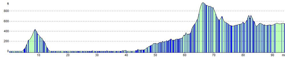
The walk begins on Holy Island next to Lindisfarne Priory (video below) and heads to Belford before starting the wonderful coastal section from Bamburgh to Warkworth. The Northumberland coastline is really beautiful, passing Bamburgh Castle (video below), Beadnell Bay, Embleton Bay, Dunstanburgh Castle and Alnmouth Bay before finishing at Warkworth near the castle.
The route then heads inland along the River Coquet to Rothbury before turning south through the Simonside Hills and Harwood Forest to Kirkwhelpington.
The final section joins Hadrian's Wall at Halton Shields and leads you to the finish point at St Oswald's Church in Heavenfield. The church is believed to be the location where King Oswald (604 -642) raised a large wooden cross before the Battle of Heavenfield.
The walk is often completed in the following sections:
1. Holy Island to Bamburgh (19 miles / 31 km)
2. Bamburgh to Craster (14 miles / 22 km)
3. Craster to Warkworth (13.5 miles / 21.5 km)
4. Warkworth to Felton and Rothbury (18 miles / 29 km)
5. Rothbury to Kirkwhelpington (15 miles / 24 km)
6. Kirkwhelpington to Heavenfield (17.5 miles / 28.5 km)
Please scroll down to the bottom for the GPX download.
Please click here for more information
St Oswald's Way Ordnance Survey Map  - view and print off detailed OS map
St Oswald's Way Open Street Map  - view and print off detailed map
*New* - Walks and Cycle Routes Near Me Map - Waymarked Routes and Mountain Bike Trails>>
St Oswald's Way OS Map  - Mobile GPS OS Map with Location tracking
St Oswald's Way Open Street Map  - Mobile GPS Map with Location tracking
Explore the Area with Google Street View 
Pubs/Cafes
Near Rothbury you will pass close to the pretty village of Thropton which is worht a slight detour from the route. Here you'll find the excellent Three Wheat Heads Inn. The main advantage here is a wonderful large beer garden with wide ranging views of the surrounding countryside and hills. If the weather is fine it's the ideal spot to relax outside and enjoy a drink. The pub also has an interesting history, dating all the way back to the 18th century. They are dog friendly and do great food in the bar and the restaurant area. You can find the inn on Front Street at postcode NE65 7LR.
The Black Swan in Belford serves good food and real ale. You can find them at the Market Place at postcode NE70 7ND.
Further Information and Other Local Ideas
Around Felton you'll pass the historic Brinkburn Priory. The 12th century Augustinian Priory church is run by English and Heritage and is a bit of hidden gem of the area. The restored church is one of the best examples of early Gothic architecture in Northumberland.
Near Rothbury you'll pass the wonderful Cragside Country Park which is well worth a slight detour from the route.
Part of the route is coincident with the Northumberland Coast Path which takes you to Berwick, visiting several of the area's historic castles on the way.
For more walking ideas in the area see the Northumberland Walks page.
Cycle Routes and Walking Routes Nearby
Photos

Gate on St Oswald's Way at Todridge Fell. The 156 Km long trail which runs from Heavenfield near Hexham to Holy Island on the Northumberland coast (although more commonly walked in the opposite direction). At this point on Todridge Fell, the Way follows a grassy bridleway alongside a wall, with extensive views to the north to Hallington and far beyond.

Footbridge over Grain Sike St Oswald's Way. Here the footpaht is seen crossing Grain Sike; the hill is the Beacon, a side peak of Simonside.

Hole in the wall, St Oswald's Way near Knowesgate. Unusually, the lower course of the wall is laid with much larger stones than the upper courses. Catcherside can be seen on the skyline.

Old bridge piers near Wagtail Farm, Rothbury. The roadway follows the line of the Northumberland Central Railway which ran from Scots Gap to Rothbury. The line was opened in 1870; passenger services ceased in 1952 and the line was finally closed in 1963. The bridge piers once supported an overbridge which crossed the railway. The trail follows part of the road picture here.

Elyhaugh Farm seen through the trees is a bed and breakfast establishment.

On the trail approaching Hallington. Here the Way follows the lane between Bingfield and Hallington. You can take a small detour from the trail here to visit the nearby Hallington Reservoir to the west of the village. The two pretty lakes are good for flora and fauna with attractive Scots pine woodland and wildlife including wigeon, teal and dunlin.

Walkers on the trail in Harwood Forest

New Bingfield. Here, the Way drops off the high land at Todridge Fell towards New Bingfield, passing a pine plantation, with a young deciduous plantation further down hill.
Elevation Profile