Wainstones Walk
![]()
![]() Climb Hasty Bank Hill and visit the fascinating Wainstones on this circular walk in the North York Moors. The Wainstones are a series of sandstone rocky outcrops with a number of interesting Bronze Age carvings. They are located near the village of Great Broughton and make for a splendid walking destination.
Climb Hasty Bank Hill and visit the fascinating Wainstones on this circular walk in the North York Moors. The Wainstones are a series of sandstone rocky outcrops with a number of interesting Bronze Age carvings. They are located near the village of Great Broughton and make for a splendid walking destination.
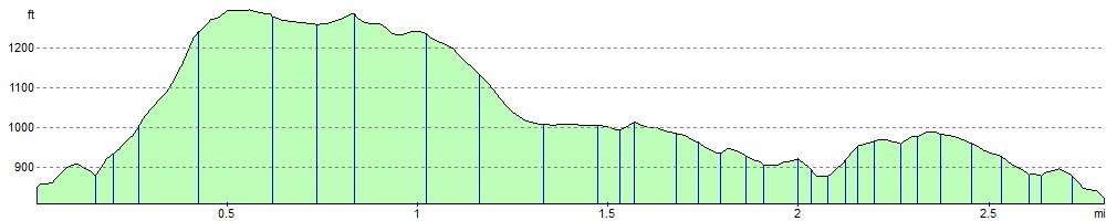
This walk begins at the car park on Clay Bank Road and climbs Hasty Bank using the Cleveland Way National Trail. From the summit there are wonderful views of the Tees Valley and the nearby Roseberry Topping and Urra Moor.
The route then descends on an adjacent footpath, passing Hasty Bank Farm before arriving back at the car park. This is a challenging walk but the footpaths are generally good and you are rewarded with truly wonderful views of the North York Moors for most of the way.
If you'd like to continue your walking in the area then simply continue west along the Cleveland Way and visit the Lord Stones. This country park also features a number of ancient stones with prehistoric carvings. There's also a fantastic viewpoint on Cringle Moor with a viewfinder detailing several landmarks you can see. The Lord Stones Cafe is a great place for refreshments with a good menu and outdoor seating.
You could also head to the nearby Roseberry Topping and Captain Cook's Monument for more great climbing and fabulous views.
The long distance Lyke Wake Walk passes the stones. The challenging walk is a complete crossing of the North Yorkshire Moors from west to east.
The Urra Moor walk also starts from the Clay Bank car park so you could pick this up and head to Round Hill, the highest point on the North York Moors.
Postcode
TS9 7JA - Please note: Postcode may be approximate for some rural locationsWainstones Ordnance Survey Map  - view and print off detailed OS map
Wainstones Open Street Map  - view and print off detailed map
*New* - Walks and Cycle Routes Near Me Map - Waymarked Routes and Mountain Bike Trails>>
Wainstones OS Map  - Mobile GPS OS Map with Location tracking
Wainstones Open Street Map  - Mobile GPS Map with Location tracking
Explore the Area with Google Street View 
Pubs/Cafes
The village of Great Broughton is located about 1.5 miles north of the stones. You can reach the village by descending north on Bank Lane. In the village there's several lovely country pubs where you can enjoy refreshments after your walk. The Bay Horse has a picturesque beer garden, perfect for relaxing in when the weather is fine. Inside there's an attractive, cosy interior with real log fires. You can find the pub on the High Street at postcode TS9 7HA for your sat navs. The Jet Miners Inn is also on the High Street and is another good option.
Dog Walking
The area is great for a dog walk but please keep them on a short lead during the spring and summer months as birds are nesting in the area.
Further Information and Other Local Ideas
If you'd like to come by public transport then you could catch the train to Battersby. The station is located on the Esk Valley Line 11 miles (18 km) south of Middlesbrough. From there you would walk south through the village of Ingleby Greenhow and then follow Lamb's Lane and Greenhow Avenue south. This would then lead you to the start point for the walk.
From nearby Lord Stones Park you can visit Carlton Bank on Carlton Moor and enjoy more fine views. The 9 mile circular Carlton in Cleveland Walk starts from the village to the north and takes in Lord Stones, Carlton Bank and Whorl Hill. The village has a final local pub for post exercise refreshments as well.
Cycle Routes and Walking Routes Nearby
Photos

The Wainstones on Hasty Bank.

The Wain Stones a different view

View of Cold Moor from the stones, a climbers' playground. Cold Moor across Garfit Gap clearly shows the scars left by jet workings in the eighteenth and early nineteenth centuries.

The Cleveland Way descends from a minor summit (402 metres) in the west of the square on a recently (1999) repaved path. Beyond it climbs again to a popular climbing area known as the Wainstones, here shrouded in low cloud. The scarp face of the North York Moors plateau falls away steeply to the left (north) towards Great Broughton with Broughton Plantation covering most of that slope.

Heading east on the Cleveland Way up to the rock outcrop.

The Sphinx Rock

Boulder Field, Below the stones. The large flat slab lying at an angle of 45 degrees contains an example of prehistoric rock art.

Atmospheric photo of hasty Bank and the stones. Before Sunrise. As seen from Cold Moor.
Elevation Profile