West Mendip Way
![]()
![]() This splendid walk takes you through the beautiful Mendip Hills Area of Outstanding Natural Beauty from Wells to Uphill.
This splendid walk takes you through the beautiful Mendip Hills Area of Outstanding Natural Beauty from Wells to Uphill.
You start in Wells by the impressive cathedral and head west towards Cheddar passing the show caves and paper mill at Wookey Hole and the wonderful limestone nature reserve at Ebbor Gorge. The route continues through Rodney Stoke National Nature Reserve and Draycott Sleights Nature Reserve before coming to the spectacular Cheddar Gorge, voted the second greatest natural wonder in Britain.
The next stage takes you through the lovely countryside at Compton Bishop before climbing across Wavering Down to Crook Peak where there are splendid views towards the coast. The final section sees you cross Bleadon Hill and finish by the wharf at Uphill on Weston Bay in Weston-Super-Mare.
West Mendip Way Ordnance Survey Map  - view and print off detailed OS map
West Mendip Way Open Street Map  - view and print off detailed map
*New* - Walks and Cycle Routes Near Me Map - Waymarked Routes and Mountain Bike Trails>>
West Mendip Way OS Map  - Mobile GPS OS Map with Location tracking
West Mendip Way Open Street Map  - Mobile GPS Map with Location tracking
Pubs/Cafes
On the walk you can take a break and head to the White Hart in Cheddar for some well earned refreshments (Postcode:BS27 3QN). Here you can enjoy a ploughman's lunch and a decent pint of Cheddar Ale in the nice beer garden.
There's also the popular Lion Rock Tea Rooms. Nestled in the heart of Cheddar Gorge in one of the oldest, most photographed and documented buildings beneath the World Famous Lion Rock. You can find it on the Cliffs Road at postcode BS27 3QE.
At the village of Wookey Hole near Wells you could stop at the The Wookey Hole Inn. The inn has an interesting interior with décor based on the local Wookey Hole caves and the old-world, new-age Glastonbury. Behind the inn there's a fantastic sculpture garden where you can sit out and enjoy your meal. There's seating for over 100 people and it's planted with bamboos, grasses and herbs. You can find the pub at postcode BA5 1BP for your sat navs. It's also dog friendly if you have your canine friend with you.
Further Information and Other Local Ideas
At the end of the route you finish at the delightful Uphill Nature Reserve. The reserve is well worth exploring with great views from the high point at Uphill Beacon and lots of interesting flora and fauna.
Cycle Routes and Walking Routes Nearby
Photos

West Mendip Way to Wavering Down. A popular bridleway, looking east away from Crook Peak. Somerset, UK.

Entering Wells. The Way follows footpath WS 17/3 down the edge of this field and past the Blue School.

The trail crosses Compton Hill, on its way to the heights of Wavering Down, on the right horizon.

Footpath above Cheddar Gorge

Crook Peak from the trail

Descending eastwards from Wavering Down

Gate near Compton Bishop

A grassy path near St Cuthbert Out
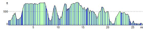
Elevation Profile