Bedford to Sandy
![]()
![]() This lovely route follows National Cycle routes 12 and 51 and the Bedford to Sandy Country Way - an off road path perfect for walking or cycling. The ride is very flat with views of the Rivers Great Ouse and Ivel plus a spell through Priory Country Park the main highlights.
This lovely route follows National Cycle routes 12 and 51 and the Bedford to Sandy Country Way - an off road path perfect for walking or cycling. The ride is very flat with views of the Rivers Great Ouse and Ivel plus a spell through Priory Country Park the main highlights.
Also on the route is the National Trust owned Willington Dovecote & Stables - a Tudor stone-built stable, built for Henry VIII's 1541 visit.
Bedford to Sandy Ordnance Survey Map  - view and print off detailed OS map
Bedford to Sandy Open Street Map  - view and print off detailed map
Bedford to Sandy OS Map  - Mobile GPS OS Map with Location tracking
Bedford to Sandy Open Street Map  - Mobile GPS Map with Location tracking
Further Information and Other Local Ideas
In Sandy you can visit the lovely Lodge Nature Reserve on the Sandy Walk. The reserve is notable as the headquarters of the RSPB and includes an excellent visitor centre with formal gardens and lots of wildlife.
On the route you'll pass the pretty village of Great Barford. There's nice river trails along the Ouse, an ancient arched bridge and a notable church with a 15th century tower.
For more walking ideas in the area see the Bedfordshire Walks page.
Cycle Routes and Walking Routes Nearby
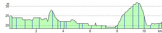
Elevation Profile