Buxton to Uttoxeter
![]()
![]() Take a trip through the lovely White Peak area of the Peak District on this challenging route which also passes by the famous Alton Towers theme park . You start by the railway station in Buxton and head south along National Cycle route 68 towards Hurdlow where you join the off road Pennine Bridleway for a short stretch. Country roads take you onto Hartington shortly before crossing the River Dove at Beresford Dale. You then join the Manifold Way - a terrific off road section that follows a dismantled railway line along the River Manifold.
Take a trip through the lovely White Peak area of the Peak District on this challenging route which also passes by the famous Alton Towers theme park . You start by the railway station in Buxton and head south along National Cycle route 68 towards Hurdlow where you join the off road Pennine Bridleway for a short stretch. Country roads take you onto Hartington shortly before crossing the River Dove at Beresford Dale. You then join the Manifold Way - a terrific off road section that follows a dismantled railway line along the River Manifold.
Country roads then take you onto Oakamoor where you join another dismantled railway line taking you along the River Churnet through the Churnet Valley.
This is where you can stop for a ride on a roller coaster if the biking isn't exciting enough!
The final section takes you through Rocester and onto Uttoxeter in Staffordshire on country roads. The route finishes by the railway station in Uttoxeter.
Buxton to Uttoxeter Ordnance Survey Map  - view and print off detailed OS map
Buxton to Uttoxeter Open Street Map  - view and print off detailed map
Buxton to Uttoxeter OS Map  - Mobile GPS OS Map with Location tracking
Buxton to Uttoxeter Open Street Map  - Mobile GPS Map with Location tracking
Further Information and Other Local Ideas
The route passes along part of the epic Pennine Cycleway which can be used to further extend your ride.
Cycle Routes and Walking Routes Nearby
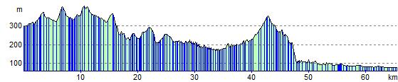
Elevation Profile