Cambridge to Ely
![]()
![]() This route follows National Cycle Route 11 and 51 through Cambridgeshire. The route starts on the River Cam in Cambridge and heads along the river and National Cycle route 11 before joining National Cycle Route 51 near Fen Ditton. A series of quiet country roads and off road paths take you to Burwell where you join National Cycle route 11 turning North West.
This route follows National Cycle Route 11 and 51 through Cambridgeshire. The route starts on the River Cam in Cambridge and heads along the river and National Cycle route 11 before joining National Cycle Route 51 near Fen Ditton. A series of quiet country roads and off road paths take you to Burwell where you join National Cycle route 11 turning North West.
Country roads then take you to a pleasant stretch through Wicken Fen and then onto another off road section along the River Ouse before reaching the finish point by the Cathedral in Ely.
Cambridge to Ely Ordnance Survey Map  - view and print off detailed OS map
Cambridge to Ely Open Street Map  - view and print off detailed map
*New* - Walks and Cycle Routes Near Me Map - Waymarked Routes and Mountain Bike Trails>>
Cambridge to Ely OS Map  - Mobile GPS OS Map with Location tracking
Cambridge to Ely Open Street Map  - Mobile GPS Map with Location tracking
Further Information and Other Local Ideas
The Lodes Way starts off at Wicken Fen. This circular walk or cycle follows National Cycle Route 11 through the Cambridgeshire Lodes, a series of ancient man made waterways created to link a series of Fenland villages to the River Cam.
Cycle Routes and Walking Routes Nearby
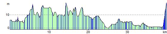
Elevation Profile