Cambridge to Waterbeach
![]()
![]() Follow the River Cam and National Cycle Route 11 on this lovely easy ride. The ride starts in the centre of Cambridge taking you past some of the famous colleges in this lovely university town.
Follow the River Cam and National Cycle Route 11 on this lovely easy ride. The ride starts in the centre of Cambridge taking you past some of the famous colleges in this lovely university town.
You will then follow the river to Waterbeach finishing at the train station. You can extend the ride on the Cambridge to Wicken Fen Cycle Route which will take you to the nearby nature reserve.
Cambridge to Waterbeach Ordnance Survey Map  - view and print off detailed OS map
Cambridge to Waterbeach Open Street Map  - view and print off detailed map
*New* - Walks and Cycle Routes Near Me Map - Waymarked Routes and Mountain Bike Trails>>
Cambridge to Waterbeach OS Map  - Mobile GPS OS Map with Location tracking
Cambridge to Waterbeach Open Street Map  - Mobile GPS Map with Location tracking
Further Information and Other Local Ideas
Near Waterbeach you can visit the delightful Wicken Fen. The nature reserve is a great place for walking and cycling with flowering meadows, reedbeds, waterways and an abundance of wildlife to see. The Lodes Way can also be picked up here. This circular walk or cycle follows National Cycle Route 11 through the Cambridgeshire Lodes, a series of ancient man made waterways created to link a series of Fenland villages to the River Cam. On the way it visits the Jacobean mansion of Anglesey Abbey. The historic site includes some beautiful gardens with ornate statues and herbaceous borders.
Cycle Routes and Walking Routes Nearby
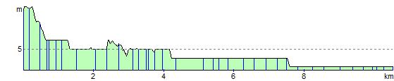
Elevation Profile