New Lipchis Way with OS Map
![]()
![]() This is an exceptionally lovely walking trail that runs from Liphook, in Hampshire, to East Head at the entrance to Chichester Harbour. The path takes you through some of the loveliest parts of West Sussex including greensand ridges,
Wealden river valleys, heathlands, high chalk downland and then finally the coastal plain at Chichester.
This is an exceptionally lovely walking trail that runs from Liphook, in Hampshire, to East Head at the entrance to Chichester Harbour. The path takes you through some of the loveliest parts of West Sussex including greensand ridges,
Wealden river valleys, heathlands, high chalk downland and then finally the coastal plain at Chichester.
The first section of the walk runs from Liphook to Midhurst, passing through Woolbeding Common before a waterside section along the River Rother takes you to Midhurst.
From Midhurst you continue south through countryside and woodland to Singleton where you will find the fascinating Weald & Downland Open Air Museum. The museum covers 50 acres, with around 50 historic buildings dating from the thirteenth to nineteenth centuries, along with gardens, farm animals, walks and a lake.
The next section then takes you to Chichester, and includes a climb to the top of St Roche's hill where you can enjoy splendid views of the South Downs. Soon after you join a short easy section along a dismantled railway line through Lavant and onto the beautiful cathedral city of Chichester.
The final section then takes you along the Chichester Ship Canal and the Chichester Channel to West Wittering with splendid views of Chichester Harbour as you go.
New Lipchis Way Ordnance Survey Map  - view and print off detailed OS map
New Lipchis Way Open Street Map  - view and print off detailed map
*New* - Walks and Cycle Routes Near Me Map - Waymarked Routes and Mountain Bike Trails>>
New Lipchis Way OS Map  - Mobile GPS OS Map with Location tracking
New Lipchis Way Open Street Map  - Mobile GPS Map with Location tracking
Pubs/Cafes
The Cowdray Farm Shop & Cafe in Midhurst is a lovely place to stop for refreshments on the trail. It serves a fine range of meals and snacks with locally sourced food. There's also fine views of the Cowdray Catle estate to enjoy with your meal. You can find it at postcode GU29 0AJ for your sat navs. It's also dog friendly if you have your canine friend with you.
In the town in Midhurst you can visit the noteworthy Royal Oak. The 17th century pub includes a splendid large garden area with an outdoor grill. It's a lovely place to relax with a meal on finer days. You can find them near Goodwood on Oaklands Lane at a postcode of GU29 0EP for your sat navs.
In Liphook there's the 17th century Deers Hut to investigate. The historic pub is set in a former Queen Anne Hunting Lodge dating back to the 1600's. They serve a delicious Sunday lunch and have a lovely garden to sit out in on warmer days. You can find them at Longmoor Rd, Griggs Green, GU30 7PD.
Further Information and Other Local Ideas
In Midhurst you will pass through the lovely Cowdray Park. This expansive estate is well worth further exploration. There's miles of trails taking you to a ruined castle and a noteworthy ancient oak. In this area you can also pick up the circular Midhurst Way which will take you to the splendid Arundel Castle and Arundel Park.
Around Chichester the route is coincident with the Centurion Way. This shared cycling and walking trail runs along the old Midhurst and Chichester railway track to West Dean.
For more walking ideas in the area see the Hampshire Walks, Sussex Walks and the South Downs Walks pages.
Cycle Routes and Walking Routes Nearby
Photos

Ingleby House on the trail

Trough with building and pond on the New Lipchis Way. This is close by Upper North Park Farm.

Hide by Hartley Green Copse

View of Cowdray ruins seen from the New Lipchis Way. At this point the long distance path turns right along the banks of the Rother.
The site consists of the ruins of one of England's great Tudor houses, architecturally comparable to many of the great palaces and country houses of that time. It is situated in the Parish of Easebourne, just east of Midhurst, West Sussex standing on the north bank of the River Rother. It was largely destroyed by fire on 24 September 1793, but the ruins have nevertheless been Grade I listed.

Waymarks on The Trundle gatepost. Popular place for walkers where the West Sussex Literary Trail, The Monarch's Way and the New Lipchis Way all pass. (The original Lipchis Way also passed here in its day.)
The Iron Age Hillfort sits in an elevated position on St Roche's Hill above Goodwood Racecourse, just to the south of the village of Singleton. It's one of the highlights of the walk and provides wonderful views over the South Downs.

Donnington. The bridge over the Chichester Ship Canal on the B2201, looking southwest.

Alongside the Chichester Canal

The New Lipchis Way meets the Romans. The Chichester Road Gang" is a sculpture by David Kemp to mark the place where the line of the old Roman road crosses the modern footpath. The road bridge beyond carries the Hunters Race.
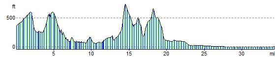
Elevation Profile