Chiseldon Timberland Trail along the Swindon to Marlborough Railway Path
![]()
![]() This short easy cycle or walk trail runs from Swindon to Chiseldon along the old Swindon to Marlborough railway line.
This short easy cycle or walk trail runs from Swindon to Chiseldon along the old Swindon to Marlborough railway line.
The trail starts near Swindon Country Cricket Ground and heads to the lovely Coate Water Country Park where you can hire boats or try your hand at the crazy golf. The route then joins the disused railway path which takes you to Chiseldon and includes a stretch through a delightful bluebell wood. For walkers the best start point is at Coate Water where there is parking next to the trail start.
To continue your cycling around Swindon see our circular Swindon Cycle Route which visits several of the parks in the town.
Please click here for more information
Chiseldon Timberland Trail Ordnance Survey Map  - view and print off detailed OS map
Chiseldon Timberland Trail Open Street Map  - view and print off detailed map
Chiseldon Timberland Trail OS Map  - Mobile GPS OS Map with Location tracking
Chiseldon Timberland Trail Open Street Map  - Mobile GPS Map with Location tracking
Cycle Routes and Walking Routes Nearby
Photos

View to the south-east across Coate Water, Swindon Taken at dusk. Just visible in the centre of the image and about 1.4 kilometres away, is the Great Western Hospital

Church Street, Chiseldon, Swindon. Out of view to the left is Holy Cross church. In the left foreground is the entrance to Parsonage Farm.

The cycleway to Chiseldon

The Council Oak at Coate Water
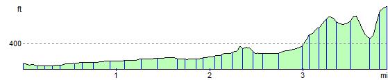
Elevation Profile