Swindon Cycle Routes
![]()
![]() This Wiltshire town has several good options for cyclists with a number of waymarked cycling trails to try. This long circular ride uses several of these trails to take you around the town, visiting three lovely country parks on the way.
This Wiltshire town has several good options for cyclists with a number of waymarked cycling trails to try. This long circular ride uses several of these trails to take you around the town, visiting three lovely country parks on the way.
The ride starts at the train station and heads west along the Station Link and the Western Flyer to Westlea. Here you pick up a section of the West Swindon Round to take you through Toothill and Freshbrook. The route bends round to Lydiard Country Park. The park contains 260 acres of lawns, woodlands and pasture with a mixture of footpaths and cycle routes to try.
After leaving the park you continue through Roughmoor to Shaw Forest Park where you pick up National Cycle Route 45. Follow this north and it will take you to Mouldon Hill Country Park.
The route then heads east along the Urban Round before picking up the Haydon Wick Round at Abbey Meads. This leads you south through Seven Fields to Pinehurst and back to the train station. Here you pick up the rail link again and follow it south east to join with the Dorcan Round. Follow this further south east and you can visit Coate Water Country Park where there's a traffic free cycle trail to follow between the lakes. From here you can also pick up NCN route 45 again and follow it west through Lawns Park and the Old Town. This will eventually lead you back to Westmead where you can pick up the rail link to take you back to the station.
The town is also well served by two traffic free cycle trails along disused railway lines. See the Chiseldon and Marlborough Railway Path and Chiseldon Timberland Trail pages for more details.
Swindon Ordnance Survey Map  - view and print off detailed OS map
Swindon Open Street Map  - view and print off detailed map
Swindon OS Map  - Mobile GPS OS Map with Location tracking
Swindon Open Street Map  - Mobile GPS Map with Location tracking
Cycle Routes near Swindon
- Swindon to Cirencester - This route follows National Cycle Route 45 from Wiltshire to Gloucestershire taking you through a lovely part of the Cotswolds
- Salisbury to Swindon - This ride takes you through the heart of Wiltshire along National Cycle Route 45 with the famous Stonehenge as a major route highlight
- Chiseldon and Marlborough Railway Path - This is a nice easy cycle or walking route along the now disused Chiseldon and Marlborough Railway.
It starts in Marlborough where you cross the River Kennet and head into the countryside along the path - Coate Water Country Park - This is a short circular walk around the delightful Coate Water Country Park in Swindon
- Mouldon Hill Country Park - This pretty country park near Swindon has some nice footpaths to follow through the site
- Shaw Forest Park - Enjoy some nice walking trails in this community woodland in Swindon
- Barbury Castle Country Park - Barbury Castle Country Park is a Scheduled Ancient Monument, Local Nature Reserve in the North Wessex Downs Area of Outstanding Natural Beauty
- Hackpen Hill - This circular walk visits the Hackpen White Horse hill figure on the Marlborough Downs.
- Ridgeway Circular Walk - Aldbourne - This circular route on the Wiltshire Downs explores the area around the village of Aldbourne
- Chiseldon Timberland Trail - This short easy cycle or walk trail runs from Swindon to Chiseldon along the old Swindon to Marlborough railway line.
The trail starts near Swindon Country Cricket Ground and heads to the lovely Coate Water Country Park where you can hire boats or try your hand at the crazy golf - Lydiard Park - Located on the edge of Swindon is this splendid park with 260 acres of lawns, woodlands and pasture for visitors to walk or cycle through
- South Swindon Green Trail - This circular walk around Swindon follows the boundary of the parish, visiting several local scenic highlights on the way.
Further Information and Other Local Ideas
Near Coate Water you could pay a visit to the fascinating Richard Jeffries Museum. Jeffries was a Victorian nature writer with a passion for the English countryside. He even gave us a name for it all: wild life. He was born in Swindon at Coate in the delightful 17th century thatched house which is now a museum to his life and work. The house is also surrounded by lush gardens making it a lovely place for a stroll near the town. You can find the museum at postcode SN3 6AA, just to the north east of Coate Water.
Photos
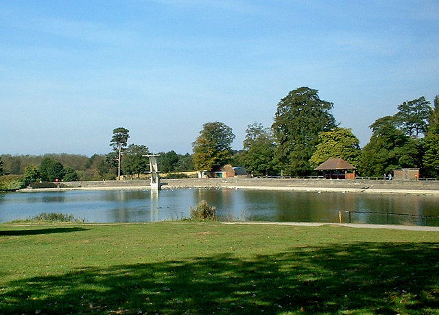
Coate Water. This is part of the lake (former canal reservoir) known as Coate Water. It and the surrounding walks and parkland are now known as Coate Water Country Park. In the distance, on the opposite side, can be seen the diving board. This is no longer in use, and hasn't been for several decades, because of problems with the lake's water which prevents swimming.


