Cuerden Valley Park Walks and Cycling
![]()
![]() This lovely short ride or walk takes you through the Cuerden Valley Country Park in Bamber Bridge, Lancashire.
This lovely short ride or walk takes you through the Cuerden Valley Country Park in Bamber Bridge, Lancashire.
The trail takes place on largely traffic free paths through the park. Here you'll find attractive woodland in the Pinetum, a lake and views of the River Lostock which runs through the eastern part of the park.
The route starts and ends at Lostock Hall train station but can be easily accessed from Preston, Chorley or the access point at the southern end next to the village of Whittle Le Woods. There's also a good sized car park at the site.
Postcode
PR5 6BY - Please note: Postcode may be approximate for some rural locationsPlease click here for more information
Cuerden Valley Park Ordnance Survey Map  - view and print off detailed OS map
Cuerden Valley Park Open Street Map  - view and print off detailed map
Cuerden Valley Park OS Map  - Mobile GPS OS Map with Location tracking
Cuerden Valley Park Open Street Map  - Mobile GPS Map with Location tracking
Pubs/Cafes
The on site Cuerden View Cafe is a great place for some refreshment. They serve a good range of meals and have a lovely outdoor terrace area with views over the park.
Dog Walking
The woodland and parkland trails are ideal for dog walking so you'll probably see other owners on your visit. The on site cafe mentioned above is also dog friendly.
Further Information and Other Local Ideas
The Chorley Circular Walk explores the area around Chorley on public footpaths. It visits the park and also the canal and the nearby Yarrow Valley country park. You can also pick up the Chorley Loop Cycle Route here. The circular trail explores the local area visiting the Leeds and Liverpool Canal, Astley Park and Yarrow Valley Country Park, all of which are great for cycling.
Head a few miles north west to Leyland and you can enjoy similar walking trails around the expansive Worden Park. The site includes woodlands, a duck pond, a folly, a water cascade, a mininiture railway, a popular mazae, an 18th Century domed icehouse and waterside trails along the Shaw Brook which runs through the park.
For more walking ideas in the area see the Lancashire Walks page.
Cycle Routes and Walking Routes Nearby
Photos

Gate between the car park and the pinetum, Cuerdon Valley Park.

Lake at the park. You can look out for various wildfowl on the water here.

Junction of several paths in the valley. All these paths are meeting near the stone bridge over the River Lostock. The picnic area is just on the other side of the bridge.

Two gates. The walk through the gate on the right goes down to the River Lostock. The larger gate on the left is the entrance to the field where the local riding school keep their horses.

River Lostock view.

The Barn, visitor centre, Berkeley Drive. The Barn is the name of the visitor centre. It is also the home of The Cuerdon Valley Trust and the local branch of The Wildlife Trust.

Old stone gateway and path. This old stone gateway is set into an ancient wall. The path leads from the pinetum to the River Lostock.

This path leads from the main track to Cuerdon Hall.
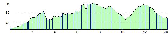
Elevation Profile