Exe Valley Cycle Trail
![]()
![]() This lovely easy ride or walk follows the River Exe, the Exeter Canal and National Cycle Route 2 from Exeter to Exminster.
This lovely easy ride or walk follows the River Exe, the Exeter Canal and National Cycle Route 2 from Exeter to Exminster.
Highlights include Exeter's attractive quay, views of the Exe esutaury and the Riverside Valley Park.
Exe Valley Ride Ordnance Survey Map  - view and print off detailed OS map
Exe Valley Ride Open Street Map  - view and print off detailed map
Exe Valley Ride OS Map  - Mobile GPS OS Map with Location tracking
Exe Valley Ride Open Street Map  - Mobile GPS Map with Location tracking
Further Information and Other Local Ideas
Just a few miles north east of the city there's the wonderful Killerton Park Estate to explore. The National Trust owned park covers thousands of acres with miles of great cycling and walking trails surrounding the 18th century mansion. On the northern end of the estate you will find the Ellerhayes Bridge and the River Culm Walk. There's another small car park here next to the photogenic 15th century bridge. You can park here and enjoy a stroll along the River Culm with more lovely views to enjoy.
The historic village of Broadclyst and the peaceful woodland trails around Ashclyst Forest can also be found in this area.
Cycle Routes and Walking Routes Nearby
Photos

The River Exe South of the A377 bridge, Exeter

Exeter Canal beside the cycle path

The Exeter Ship Canal

Exeter canal
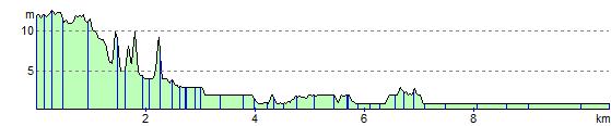
Elevation Profile