Gloucester to Tewkesbury
17.4 miles (28 km)
![]()
![]() This route follows National Cycle Route 45 through the Vale of Gloucester.
This route follows National Cycle Route 45 through the Vale of Gloucester.
The route starts near the Cathedral in Gloucester and after leaving the town heads north along the Severn Way. The route continues on minor roads following the river to Tewkesbury.
Gloucester to Tewkesbury Ordnance Survey Map  - view and print off detailed OS map
Gloucester to Tewkesbury Open Street Map  - view and print off detailed map
Gloucester to Tewkesbury OS Map  - Mobile GPS OS Map with Location tracking
Gloucester to Tewkesbury Open Street Map  - Mobile GPS Map with Location tracking
Cycle Routes and Walking Routes Nearby
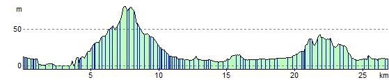
Elevation Profile