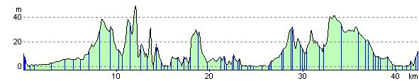
Gravesend to Sittingbourne
28 miles (45 km)
![]()
![]() Starting in Gravesend on the banks of the river Thames follow National Cycle route 1 to Sittingbourne via Rochester and Gillingham.
Starting in Gravesend on the banks of the river Thames follow National Cycle route 1 to Sittingbourne via Rochester and Gillingham.
The route starts by heading east to Upnor where you join the River Medway and pass the impressive Upnor Castle. You then head through Rochester with its splendid castle before continuing along the river through Riverside Country Park in Gillingham. The final stretch is mostly on road taking you into Sittingbourne and finishing with a pleasant spell along Milton Creek Country Park.
Gravesend to Sittingbourne Ordnance Survey Map  - view and print off detailed OS map
Gravesend to Sittingbourne Open Street Map  - view and print off detailed map
Gravesend to Sittingbourne OS Map  - Mobile GPS OS Map with Location tracking
Gravesend to Sittingbourne Open Street Map  - Mobile GPS Map with Location tracking
Cycle Routes and Walking Routes Nearby
Elevation Profile