Sittingbourne Walks
![]()
![]() This Kentish town has some fine river and coastal walking to try nearby.
This Kentish town has some fine river and coastal walking to try nearby.
This circular walk around Sittingbourne visits Milton Creek Country Park and Little Murston Nature Reserve on the Swale. Both of these scenic sites are easily reachable on foot from the town centre.
The walk starts at the train station where you can pick up the Saxon Shore Way and follow the waymarked footpath north along the Milton Creek to Milton Creek Country Park. The 128 acre park includes some nice trails along the park's lakes and waterways.
The route then crosses the creek and heads north along the Saxon Shore Way to Little Murston Nature Reserve. There's some pretty lakes and views of the Swale with lots of wildfowl to look out for in this area. At the reserve you can also pick up the River Swale Heritage Trail which can be followed east to Conyer. This route heads south along the Saxon Shore Way to return you to the town centre via Murston and Bayford.
Sittingbourne Ordnance Survey Map  - view and print off detailed OS map
Sittingbourne Open Street Map  - view and print off detailed map
*New* - Walks and Cycle Routes Near Me Map - Waymarked Routes and Mountain Bike Trails>>
Sittingbourne OS Map  - Mobile GPS OS Map with Location tracking
Sittingbourne Open Street Map  - Mobile GPS Map with Location tracking
Walks near Sittingbourne
- Milton Creek Country Park - A short circular cycle or walk around Milton Creek Country Park in Sittingbourne in Kent
- North Downs Way - This beautiful trail starts in Farnham, Surrey and heads east through the stunning North Downs to the historic city of Canterbury in Kent
- Pilgrims Way - Follow in the footsteps of the pilgrims who followed this ancient track from Winchester in Hampshire, to the shrine of Thomas Becket at Canterbury in Kent
- Leeds Castle Maidstone - Explore the stunning grounds of this 19th century castle and former residence of Catherine of Aragon. There are 500 acres of beautiful parkland, open water and formal gardens to explore on well laid out walking paths.
- Maidstone River Walk - A nice riverside walk along the Medway from Maidstone to Leybourne Lakes Country Park
- Medway Valley Walk - This is a lovely, easy riverside walk along the River Medway from Tonbridge to Rochester
- Leybourne Lakes Country Park - Enjoy peaceful, waterside walking and cycling at Leybourne Lakes Country Park, near Maidstone in Kent
- Saxon Shore Way - Explore Kent's ancient coastline as you visit Iron Age hill forts, cathedrals, Martello towers, historic ports and castles on this incredible 160 mile walk
- Swale Heritage Trail - Travel through Kent along the Swale Heritage Trail from Murston to Goodnestone
- Isle of Sheppey - The Isle of Sheppey is located of the north coast of Kent
- Faversham - This lovely Kent based town has nice trails to follow along Faversham Creek and the Swale Estuary
- Faversham to Whitstable - A popular walk along a section of the Saxon Shore Way from Faversham to Whitstable
- Oare Marshes - This beautiful nature reserve near Faversham has nice trails to follow along the Swale estuary and Oare Creek
- Conyer - This little Kent based village has some nice waterside walks along the Conyer Creek and the Swale River.
- Bearsted - This attractive Kent based village has a pretty village green, a local community run woodland park and easy access to the footpaths on the North Downs.
Pubs/Cafes
The Red Lion is a good choice for some post walk refreshment in the town. They do a find Sunday roast and have a nice outdoor area too. You can find them on the High Street at postcode ME10 4PB for your sat navs. The pub is also dog friendly.
Further Information and Other Local Ideas
Head north across the Swale and you could explore the nearby Isle of Sheppey where there's some good coastal trails to try.
If you continue east then you could visit Conyer Creek and Faversham where you can explore the Oare Marshes and pick up the Faversham to Whitstable Walk.
For more walking ideas in the area see the Kent Walks page.
Photos
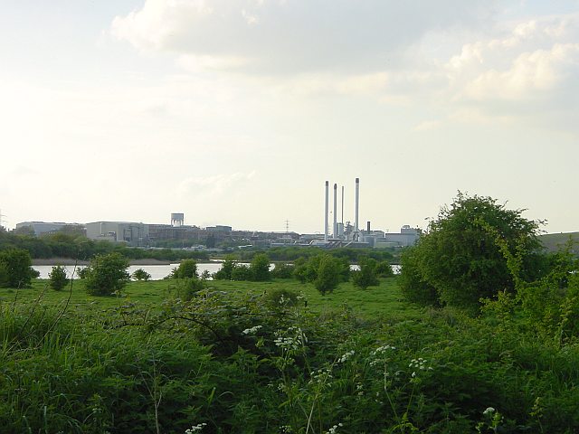
Milton Creek. Looking south from just beyond Kemsley Down station (Sittingbourne and Kemsley Light Railway). Once an important waterway, but now unused and probably unknown to most Sittingbourne residents. The water tower and buildings around it are at Sittingbourne Mill.
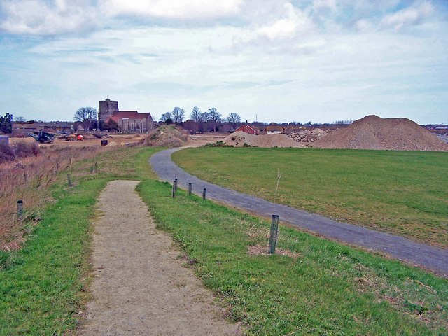
Church Marshes Country Park in 2008. Now Milton Creek Country Park. The completed part of the groundwork comes to an abrupt halt at this point. The site was a former landfill tip which is being buried under a massive quantity of infill to create the country park. The church is Holy Trinity, Milton Regis.
Fishing pond in Milton Creek Country Park. This pond existed long before the Country Park had been created. It was possibly originally a clay pit for the local brickworks. The pond has now been tidied up, with new paths and fishing access platforms. A permit is required to fish here.
Light railway viaduct and steam pipe. The light railway line was built to carry both raw materials and finished paper products between Bowater's paper mills at Sittingbourne and Kemsley. It runs on this low concrete viaduct which has been decaying steadily over the years. The railway line is kept open by a group of enthusiasts who run steam trains on it through the summer and have done a lot of work in recent years to maintain the viaduct.


