Lampeter to Aberystwyth
![]()
![]() This lovely ride follows National Cycle route 82 and the beautiful Ystwyth trail from Lampeter to the coastal Aberystwyth.
This lovely ride follows National Cycle route 82 and the beautiful Ystwyth trail from Lampeter to the coastal Aberystwyth.
You start in Lampeter following the River Teifi to Tregaron on quiet country roads. Here you join the Ystwyth Trail cycleway which takes you all the way to Aberystwyth on off road tracks which follow a disused railway line. The trail takes you through the splendid Cors Caron with its variety of wildlife, and then along the River Ystwyth to the finish point on the sea front in Aberystwyth.
Lampeter to Aberystwyth Ordnance Survey Map  - view and print off detailed OS map
Lampeter to Aberystwyth Open Street Map  - view and print off detailed map
Lampeter to Aberystwyth OS Map  - Mobile GPS OS Map with Location tracking
Lampeter to Aberystwyth Open Street Map  - Mobile GPS Map with Location tracking
Pubs/Cafes
After your exercise head to The Glengower in Aberystwyth for some post cycle refreshments. The hotel is in a great location on the sea front with nice views and an outdoor seating area for the warmer months. You can find it at 3 Victoria Terrace, Aberystwyth SY23 2DH.
Cycle Routes and Walking Routes Nearby
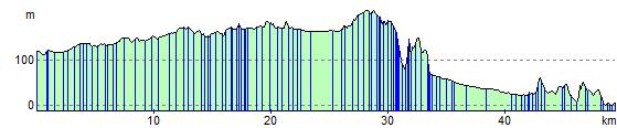
Elevation Profile