Looe to Lostwithiel
![]()
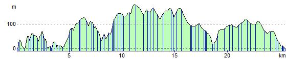
![]() This route starts on the bridge at Looe and follows the West Looe river north west before heading into the countryside towards Lostwithiel on country roads. The route finishes on another bridge, this time over the River Fowey.
This route starts on the bridge at Looe and follows the West Looe river north west before heading into the countryside towards Lostwithiel on country roads. The route finishes on another bridge, this time over the River Fowey.
Looe to Lostwithiel Ordnance Survey Map  - view and print off detailed OS map
Looe to Lostwithiel Open Street Map  - view and print off detailed map
Looe to Lostwithiel OS Map  - Mobile GPS OS Map with Location tracking
Looe to Lostwithiel Open Street Map  - Mobile GPS Map with Location tracking
Pubs/Cafes
The Jolly Sailor in Looe is a historic pub of some note. It was originally established in 1516 making it one of the oldest pubs in England. Affectionately known as 'the Jolly' by the locals, it has been a place of rest and recreation for seafarers and travellers alike for centuries. Inside the main beam in the pub was taken from a French ship of the line at the Battle of Trafalgar in 1805. The ship was captured and renamed The Indefatigable. When she was later broken up, the landlord of the time arranged for the beam to be installed in the main bar and it remains there to this day. The pub has been refurbished to a very high standard, making it one of the most pleasant, as well as the most characterful of places to drink or stay in the town. You can find the pub on Princes Square, Looe at postcode PL13 2EP.
Cycle Routes and Walking Routes Nearby
Elevation Profile