Luton to Leighton Buzzard
![]()
![]() Follow National Cycle Route 6 through Bedfordshire on this attractive route known as the Luton and South Beds Way. The route starts by Luton rail and soon passes through Wardown park with its attractive lake and the Luton Museum & Art Gallery.
Follow National Cycle Route 6 through Bedfordshire on this attractive route known as the Luton and South Beds Way. The route starts by Luton rail and soon passes through Wardown park with its attractive lake and the Luton Museum & Art Gallery.
A short section along the River Lea and a series of off road paths then lead you to Dunstable. On this section you will pass Leagrave Common and Houghton Hall Park before arrving at the pretty Grove House Gardens in Dunstable. Just south of the route is the interesting Dunstable Priory and Friary which is worth a visit if you have time.
From Dunstable you join a splendid off road section along the Sewell Greenway taking you towards Stanbridge before a series of quiet roads takes you into Leighton Buzzard where you will cross the Grand Union Canal before finishing at the train station.
Luton to Leighton Buzzard Ordnance Survey Map  - view and print off detailed OS map
Luton to Leighton Buzzard Open Street Map  - view and print off detailed map
*New* - Walks and Cycle Routes Near Me Map - Waymarked Routes and Mountain Bike Trails>>
Luton to Leighton Buzzard OS Map  - Mobile GPS OS Map with Location tracking
Luton to Leighton Buzzard Open Street Map  - Mobile GPS Map with Location tracking
Further Information and Other Local Ideas
In Leighton Buzzard you can take a small detour from the route to visit Ascott House. The National Trust owned house dates from the 16th century and is surrounded by some beautiful parkland and gardens. Near here you can also visit the historic village of Mentmore where you will find interesting old buildings associated with the 19th century Mentmore Towers Estate.
Cycle Routes and Walking Routes Nearby
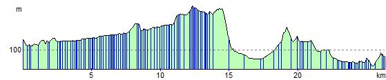
Elevation Profile