Manchester to Macclesfield
28 miles (45 km)
![]()
![]() Follow National Cycle routes 6, 62 and 55 through Manchester and Cheshire on this lovely ride. You start by Manchester Oxford Road station heading south through Chorlton to the River Mersey. Here you join a lovely traffic free section along the Trans Pennine Trail which takes you to Stockport passing Chorlton Water Park on the way. You then pass through Bredbury where you join another off road stretch by the River Goyt which takes you to Marple. At Marple you then join the Middlewood Way - a lovely off road cycle path running from Macclesfield to Marple and passing by the Macclesfield Canal and the town of Bollington.
Follow National Cycle routes 6, 62 and 55 through Manchester and Cheshire on this lovely ride. You start by Manchester Oxford Road station heading south through Chorlton to the River Mersey. Here you join a lovely traffic free section along the Trans Pennine Trail which takes you to Stockport passing Chorlton Water Park on the way. You then pass through Bredbury where you join another off road stretch by the River Goyt which takes you to Marple. At Marple you then join the Middlewood Way - a lovely off road cycle path running from Macclesfield to Marple and passing by the Macclesfield Canal and the town of Bollington.
Please click here for more information
Manchester to Macclesfield Ordnance Survey Map  - view and print off detailed OS map
Manchester to Macclesfield Open Street Map  - view and print off detailed map
Manchester to Macclesfield OS Map  - Mobile GPS OS Map with Location tracking
Manchester to Macclesfield Open Street Map  - Mobile GPS Map with Location tracking
Cycle Routes and Walking Routes Nearby
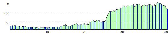
Elevation Profile