Monsal Trail
![]()
![]() Follow the Monsal Trail through the Peak District National Park on this cycling and walking path.
Follow the Monsal Trail through the Peak District National Park on this cycling and walking path.
The trail follows a disused railway line from Chee Dale near Buxton to Bakewell with the first section following the River Wye to Monsal Head via Cressbrook Dale and Miller's Dale. This popular beauty spot includes shady wooded valleys, rushing rivers and lots of interesting flora and fauna. At Monsal Head you will pass over the impressive Headstone Viaduct, built in 1836.
The second section runs onto Bakewell passing Great Longstone with more stunning views to enjoy.
You can virtually explore the route using google street view link below!
Monsal Trail Ordnance Survey Map  - view and print off detailed OS map
Monsal Trail Open Street Map  - view and print off detailed map
*New* - Walks and Cycle Routes Near Me Map - Waymarked Routes and Mountain Bike Trails>>
Monsal Trail OS Map  - Mobile GPS OS Map with Location tracking
Monsal Trail Open Street Map  - Mobile GPS Map with Location tracking
Pubs/Cafes
On the trail you can stop of at the excellent Anglers Rest in Millers Dale. This 18th-century, ivy-covered pub has a charming interior with oak beams and a roaring fire. The pub is located right next to the river so you can also sit outside and enjoy views of the Dale with your meal. You can find the pub at postcode SK17 8SN for your sat navs. Also at Millers Dale there's the Station Cafe next to the car park. The cafe does a good range of meals and snacks and is a popular stop off point for people on the trail.
Near Bakewell there's the Hassop Station Cafe housed in the old Hassop Railway Station building. They have a sun terrace on the old platform, overlooking the trail, where you can watch the world cycle by over lunch. You can find it at postcode DE45 1NW.
Just off the trail near Monsal Head you will pass the delightful village of Little Longstone. Here you can pay a visit to the excellent Packhorse Inn. This historic pub has a fine range of ales and a cosy real fire indoors. Outside there's a lovely garden area where you can relax on warmer days. You can find the pub in the pretty little village at postcode DE45 1NN. At neighbouring Great Longstone you can investigate the excellent Crispin. The inn dates back to the 1600s and includes a charming interior with ceiling beams studded with a wonderful array of beer mugs and old horse buckles. They do a fine Sunday lunch which you can enjoy in the sunny garden area. You can find them on Main Street at postcode DE45 1TZ for your sat navs. In the village there's also a noteworthy 13th century church and 18th century hall to see. You can climb north from here to the splendid limestone ridge at Longstone Edge.
Dog Walking
The woodland and river trails are ideal for dog walking and the Anglers Rest and Station Cafe mentioned above are also dog friendly.
Further Information and Other Local Ideas
You can extend your exercise by trying our Monsal Trail Circular Walk which uses part of the trail visiting Monsal Dale, Millers Dale and the village of Taddington. The Bakewell Railway Walk also creates a circular walk using the trail. It starts from Bakewell and visits Monsal Head before heading to the picture postcard village of Ashford in the Water.
For more walking ideas in the area see the Peak District Walks and White Peak Walks pages.
Cycle Routes and Walking Routes Nearby
Photos

Tunnel on the trail

Monsal Trail Viaduct. Over the River Wye.

Millers Dale along the Monsal Trail. Near to the metal railway viaducts is a wooden bridge over the water which provides this shot.

Toll Bar House
,_Derbyshire_(geograph_5666583).jpg)
Great Longstone railway station (site).
Opened in 1863 as 'Longstone' by the Midland Railway on the line from Matlock to Buxton and Manchester, this station was renamed 'Great Longstone for Ashford' in 1913. It closed to passengers in 1962 and completely in 1967. View west towards Monsal Dale and Manchester / Buxton. The Monsal Trail runs through the site but the former station house is now a private dwelling.

Hassop Station now a cafe

Looking east along the Trail from the bridge carrying the Pennine Bridleway.

Chee Dale Wormhill.
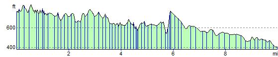
Elevation Profile