Penzance to Camborne
16 miles (25 km)

 Starting in Penzance follow National Cycle Route 3 to Camborne on this attractive route.
The route begins near the train station in Penzance and follows the off road St Michaels Way along the coast to Marazion, where you will find the lovely Marazion Marsh - an RSPB nature reserve with views of the wonderful St Michael's Mount (below).
You will then turn inland towards the Hayle Estuary where you will find a variety of birdlife. The route then heads east on off road paths and country roads to the finish point at Camborne
Penzance to Camborne Ordnance Survey Map  - view and print off detailed OS map
Penzance to Camborne Open Street Map  - view and print off detailed map
Penzance to Camborne OS Map  - Mobile GPS OS Map with Location tracking
Penzance to Camborne Open Street Map  - Mobile GPS Map with Location tracking
Cycle Routes and Walking Routes Nearby
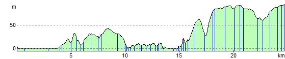
Elevation Profile