Phoenix Trail
![]()
![]() This is a lovely short flat ride running from Thame to Princes Risborough.
This is a lovely short flat ride running from Thame to Princes Risborough.
The route is largely off road and takes you along a safe tranquil path with splendid views of the Chilterns in the distance. As such it's a good one for anyone looking for a family cycle ride or an easy walk.
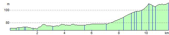
It runs for just under 7 miles along the former Princes Risborough to Oxford railway line with some interesting artwork dotted along the route too.
The route makes up part of National Cycle Route 57 which runs between Welwyn Garden City and Northleach in the Cotswolds.
Phoenix Trail Ordnance Survey Map  - view and print off detailed OS map
Phoenix Trail Open Street Map  - view and print off detailed map
Phoenix Trail OS Map  - Mobile GPS OS Map with Location tracking
Phoenix Trail Open Street Map  - Mobile GPS Map with Location tracking
Pubs/Cafes
At one end of the route in Thame The Six Bells is a good choice for refreshments. The friendly pub does very good food and has a nice outdoor seating area for warmer days. You can find the inn on the High Street at a postcode of OX9 2AD for your sat navs.
At the other end The Red Lion in Princes Risborough is worth a visit. It's a delightful village pub sat in the hamlet of whiteleaf and on The Ridgeway National Trail. There's a cosy interior and a pretty garden area where you can sit outside if the weather is favourable. You can find the pub at a postcode of HP27 0LL for your sat navs. It's also dog friendly if you have your canine friend with you.
Further Information and Other Local Ideas
In Princes Risborough you can pick up the The Ridgeway National Trail and walk up to the popular viewpoint at Coombe Hill. Here you can enjoy fine views over the Chilterns AONB.
Also in the town you can access the epic Chilterns Cycleway. The signed circular trail runs for about 170 miles through the Chilterns AONB on quiet country lanes, visiting a series of delightful villages.
Cycle Routes and Walking Routes Nearby
Photos

Animals on poles - art on the Phoenix Trail. One of the many artworks along this Sustrans cycleway from Thame to Princes Risborough

This seat and shelter is provided by Sustrans and is an artwork as well. It's located on the trail near Towersey

Sandpit lane. The trail is slightly diverted off the former track bed which is now the garden off the nearby house

Signage and countryside on the trail

The Ford. The trail follows a section of the route of the former Princes Risborough to Oxford railway line, between Princes Risborough and Thame, and was constructed by, and is currently managed, by Sustrans. After the closure of the through route between Princes Risborough and Oxford in 1967, this section from the junction with the Watlington branch line to Thame remained open until 1991 to serve the oil depot at Thame. After closure of this section the track was lifted later in the 1990s. The post on the left is one of several artworks along the route of the trail, based on observations of light at different times of the day

The Phoenix Trail enters Thame. As this cycle track enters Thame, a former railway platform is on the left, light industry on the right, a road bridge ahead.

The village of Towersey. Taken from the location of the Towersey Halt on the former railway

The surfaced path as it approaches the lane up to Grovehill Farm
Elevation Profile