Rother Valley Country Park
![]()
![]() Rother Valley Country Park is located near Sheffield and is an excellent place for a peaceful waterside walk or cycle. Here you will find 5 pretty lakes, views of the River Rother and a nature reserve which boasts the recording of over 260 different varieties of birds over the past two decades.
Rother Valley Country Park is located near Sheffield and is an excellent place for a peaceful waterside walk or cycle. Here you will find 5 pretty lakes, views of the River Rother and a nature reserve which boasts the recording of over 260 different varieties of birds over the past two decades.
Three excellent Rother Valley bike trails of varying difficulty have been created while there is also on site cycle hire available. Click here for details.
For walkers there is an extensive network of Nature trails for all abilities. These include an interesting sculpture trail and an easy lakeside route. Please click here for more information.
To extend your walking in the area we recommend heading to nearby Maltby to visit Roche Abbey. The site is located just to the south of the town and includes some fascinating 12th century ruins set in beautiful parkland. The Sheffield Country Walk also passes through the park. The circular long distance trail is a great way of extending your walking in the area. Following it a short distance north would take you to Treeton Dyke where there's more fine waterside trails to try.
Postcode
S26 5PQ - Please note: Postcode may be approximate for some rural locationsRother Valley Country Park Ordnance Survey Map  - view and print off detailed OS map
Rother Valley Country Park Open Street Map  - view and print off detailed map
Rother Valley Country Park OS Map  - Mobile GPS OS Map with Location tracking
Rother Valley Country Park Open Street Map  - Mobile GPS Map with Location tracking
Pubs/Cafes
There's an on site cafe where you can enjoy a good range of meals and snacks.
Dog Walking
The park is very popular with dog walkers so you'll probably see plenty of other owners on your visit.
Further Information and Other Local Ideas
To the north east of the park there's some more waterside trails around the pretty Langold Lake Country Park. The 300 acre park includes woodland, a nature reserve and a water park. Near here there's also Hodsock Priory to explore. The historic park is open to the public in February for the annual snowdrop walks. All year round you can explore the wider estate on a circular public footpath though.
The Eckington Walk starts in the nearby town and follows the Trans Pennine Trail to the park. The route includes a disused section of the Chesterfield Canal. The town includes the splendid Renishaw Hall where there are some beautiful grounds and gardens surrounding the old hall.
For more walking ideas in the area see the Yorkshire Walks page.
Cycle Routes and Walking Routes Nearby
Photos
Taken on a beautiful frosty Sunday morning, this track links one side of the park to the other across the lakes.
Cable Waterskiing. One of the principal attractions at Rother Valley Country Park is the cable skiing system set up in a cordoned off area at the southern end of the large lake. Participants are pulled around on a continuous cable and there can be up to eight people using it at once. This person is using a wakeboard - by far the most common type of equipment - which allows the more confident individuals to perform spectacular acrobatics with varying degrees of success. The building in the background houses changing rooms, a pro's shop and a bar.
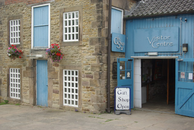
The Visitor Centre, within the Bedgreave Mill complex of buildings, dispenses information about the park and its facilities, and sells gifts.
Old railway bridge. The path is the Sothall entrance to the park. The bridge once carried the Great Central Beighton branch on to Spinkhill, Clowne and beyond. The Boiley Lane bridge crosses this line further south. To the right (south), the TPT continues on the path of the GC out to Renishaw and Staveley.
River Rother, near Waleswood. This is not the original course of the river; it was moved to the east in the 1950s to allow opencast mining to take place along the riverbed. Since then, the colliery workings have been flooded and now form the lakes of the Country Park. The river now follows a broad loop around the eastern side of the park.
Not the River Rother, Woodhouse Mill. Although this looks like part of the River Rother, the course of the river is now a couple of hundred metres to the west. The course of the river was moved in the 1950's to alleviate frequent flooding problems. This bit was left behind to provide local factories with a source of water in the event of fire. The photo looks south-west towards Woodhouse. An easy walk from this square can be taken to the Country Park.


