Rotherham to Worksop
![]()
![]() This ride takes you along National Cycle Route 6 from Yorkshire into Nottinghamshire. You start near the train station in Rotherham on the River Rother and head south towards Moorgate. The route then passes through Ulley Country Park with its lovely reservoir and wildlife.
This ride takes you along National Cycle Route 6 from Yorkshire into Nottinghamshire. You start near the train station in Rotherham on the River Rother and head south towards Moorgate. The route then passes through Ulley Country Park with its lovely reservoir and wildlife.
Quiet roads then take you through Aston before a lovely traffic free stretch through Rother Valley Country Park - an award winning 750 acre park with a nature reserve, lakes and bridleways.
The route continues east on country roads, passing Harthill Reservoir, Pebley Reservoir and Old Spring Wood on the way to Shirehoaks where a pleasant roll along the Chesterfield Canal takes you into Worksop, finishing at the train station.
Rotherham to Worksop Ordnance Survey Map  - view and print off detailed OS map
Rotherham to Worksop Open Street Map  - view and print off detailed map
Rotherham to Worksop OS Map  - Mobile GPS OS Map with Location tracking
Rotherham to Worksop Open Street Map  - Mobile GPS Map with Location tracking
Pubs/Cafes
The Beehive in Harthill is a good choice for some refreshments. It has been a proper country pub for over 150 years and in 2017 it underwent a significant refurbishment. The pub still retains its country feel, mixed with a modern and friendly atmosphere. There's a good menu and a nice outdoor seating with country views, where you can relax in the summer months. You can find the pub in the village at 16 Union Street with a postcode of S267YH for your sat navs.
Cycle Routes and Walking Routes Nearby
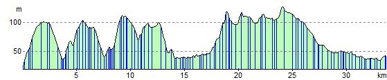
Elevation Profile