Salisbury to Stonehenge
![]()
![]() Starting in Salisbury head north to Salisbury Plain along National Cycle Route 45 and enjoy the unusual atmosphere at famous Stonehenge.
Starting in Salisbury head north to Salisbury Plain along National Cycle Route 45 and enjoy the unusual atmosphere at famous Stonehenge.
You start at the beautiful Salisbury Cathedral and head through the north gate before joining the River Avon which you follow to the outskirts of the town. The route then passes the ancient settlement of Old Sarum before rejoining the river to West Amesbury via Woodford Bridge. A short on road stretch then takes you to Stonehenge, part of the National Trust's Stonehenge Landscape.
To extend your cycling in the area try the The Golden Way circular ride. Some of the MOD's Imber Range Perimeter Path on Salisbury Plain is also suitable for cyclists.
Salisbury to Stonehenge Ordnance Survey Map  - view and print off detailed OS map
Salisbury to Stonehenge Open Street Map  - view and print off detailed map
Salisbury to Stonehenge OS Map  - Mobile GPS OS Map with Location tracking
Salisbury to Stonehenge Open Street Map  - Mobile GPS Map with Location tracking
Pubs/Cafes
There's lots of good options in nearby Amesbury and Durrington for refreshments but we'd recommend a trip down to the nearby village of Upper Woodford. Here you'll find the splendid Bridge Inn. The main attraction here is the lovely, large riverside garden area where you can relax and enjoy refreshments in an idyllic setting. Indoors there's a nice light country-style decor with sofas. They also have a very good menu and drinks selection. You can find the inn a couple of miles south of Stonehenge, in Upper Woodford, right next to the River Avon. Postcode for your sat navs is SP4 6NU.
Cycle Routes and Walking Routes Nearby
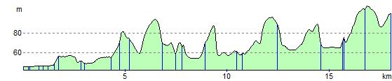
Elevation Profile