Sheffield to Barnsley
31.1 miles (50 km)
![]()
![]() This route follows the Trans Penine Trail and National Cycle routes 6, 67 and 62 to Barnsley from Sheffield.
This route follows the Trans Penine Trail and National Cycle routes 6, 67 and 62 to Barnsley from Sheffield.
You start near the cathedral in Sheffield and follow National Cycle Route 6 to Meadowhall along the River Don. At Meadowhall you join National Cycle Route 67 which takes you through Concord Park, Grenoside Woods and the lovely Wharncliffe Woods and Nature Reserve with its scenery and wildlife.
There are also views of Wharncliffe Crags and the River Don on this excellent traffic free section along the Trans Pennine Trail leading you to Oxspring where you join National Cycle Route 62. This final section takes you along more traffic free paths into the finish point at Barnsley.
Sheffield to Barnsley Ordnance Survey Map  - view and print off detailed OS map
Sheffield to Barnsley Open Street Map  - view and print off detailed map
Sheffield to Barnsley OS Map  - Mobile GPS OS Map with Location tracking
Sheffield to Barnsley Open Street Map  - Mobile GPS Map with Location tracking
Cycle Routes and Walking Routes Nearby
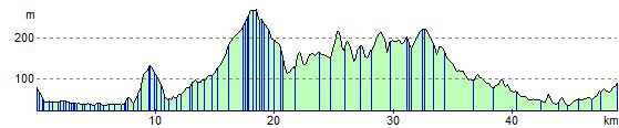
Elevation Profile