South Tyne Trail
![]()
![]() Travel through the fabulous North Pennines and enjoy some spectaular scenery on this shared walking and cycle path.
Travel through the fabulous North Pennines and enjoy some spectaular scenery on this shared walking and cycle path.
The trail starts off at Tyne Head - the source of the River South Tyne. You then head north to Garrigill along the river passing the impressive Ashgill Force waterfall as you go. The trail continues to Alston where you will run alongside the fabulous South Tynedale Steam Railway (see video).
From Alston you head through Slaggyford and Lambley where you will pass the Grade I listed Featherstone Castle and the striking structure that is Lambley Viaduct. The final section takes you through Coanwood to the finish point at Haltwhistle rail station.
This is a terrific riverside trail with moors, fells and beautiful countryside to take in.
The route links with Isaac's Tea Trail and the Pennine Way around Alston.
Please click here for more information
South Tyne Trail Ordnance Survey Map  - view and print off detailed OS map
South Tyne Trail Open Street Map  - view and print off detailed map
South Tyne Trail OS Map  - Mobile GPS OS Map with Location tracking
South Tyne Trail Open Street Map  - Mobile GPS Map with Location tracking
Pubs/Cafes
In Alston you can stop off at the 17th century Angel Inn. It dates all the way back to 1611 and has a charming interior. You can find the old inn on Front Street with a postcode of CA9 3HU for your sat navs.
Alston rail station on the heritage railway also has a nice cafe with a good choice of meals and snacks. It's a fine place to stop at while enjoying views of the old steam trains.
Near the end of the route you could enjoy some well earned rest and refreshment at The George & Dragon Inn in the village of Garrigill. The historic building dates back to 1611 with the pub opening in the early 1800s. They serve good quality home cooked food and have a good selection of ales. Inside there's a cosy interior with flagstone floors and wood burners. There are also picnic tables outside where you can relax with a lovely view of the village on warmer days.
In 2023 the pub underwent an extensive restoration project.
You can find the inn at postcode CA9 3DS for your sat navs.
Dog Walking
The walk is good place to bring your dog and the South Tynedale railway is also very dog friendly. They will provide a dog treat and also have shop selling locally made Wellybix biscuits which come in a delicious range of flavours. Dogs are welcome in all of the areas including the cafes, Discovery Centre and Engineering Workshop Viewing Gallery. Water bowls can be found at Alston station too.
Further Information and Other Local Ideas
For the full route along the river see the River Tyne Trail. This runs along Hadrian's Wall towards Hexham and Newcastle before finishing at Tynemouth at the mouth of the river.
For more walking ideas in the area see the North Pennines Walks and Cumbria Walks pages.
Cycle Routes and Walking Routes Nearby
Photos

View of the path near Haltwhistle

Car park on the South Tyne Trail near Burnstones. Trackbed of the old railway at Burnstones which once ran from Haltwhistle to Alston. Built in 1846, the line was recommended for closure by Beeching but was reprieved because there was no adequate road access to Alston in the worst of winter weather. The line was eventually closed in 1976.

South Tyne Trail at Knarsford

Slaggyford Station on the trail

Cyclists on the trail near Lambley

South Tyne Trail near Featherstone Rowfoot

Railway bridge over the South Tyne Railway Bridge over a disused stretch of the South Tyne Railway, now the South Tyne Trail. This line is unusual by the fact that from 1840 to 1976 it was standard gauge. In 1976 the re-laying of the line commenced as narrow gauge, starting at Alston.

Trail near Softley Farm
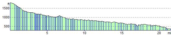
Elevation Profile