Southport to Aintree
15.5 miles (25 km)
![]()
![]() This route follows National Cycle Route 62 along the Trans Penine Trail from Southport to Aintree.
This route follows National Cycle Route 62 along the Trans Penine Trail from Southport to Aintree.
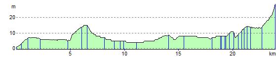
The ride is fairly flat, mainly off road and includes some lovely coastal scenery and a stretch past Royal Birkdale Golf club at the start.
There is then an easy run along a dismantled railway line through Ainsdale, Lydiate and Maghull where you join the Leeds and Liverpool Canal taking you to the finish point at Aintree - home of the famous racecourse where the Grand National takes place.
Southport to Aintree Ordnance Survey Map  - view and print off detailed OS map
Southport to Aintree Open Street Map  - view and print off detailed map
Southport to Aintree OS Map  - Mobile GPS OS Map with Location tracking
Southport to Aintree Open Street Map  - Mobile GPS Map with Location tracking
Further Information and Other Local Ideas
In Southport the route links with the Pier To Pier Cycle Route. This will take you along National Route 562 to Wigan Pier via Burscough, Appley Bridge and the easy flat towpath of the Leeds and Liverpool Canal.
Cycle Routes and Walking Routes Nearby
Elevation Profile