St Austell to Lostwithiel
![]()
![]() Follow National Cycle Route 3 from St Austell to Lostwithiel on this lovely Cornish route. The route starts near the St Austell town centre and then heads north along a dismantled railway line before turning east to Trethurgy through the China clay works. You'll then pass the wonderful Eden Project before heading north on country roads to the Helman Tor nature reserve.
The next route highlight you will come to is Lanhydrock - a magnificent country house owned by the National Trust.
Follow National Cycle Route 3 from St Austell to Lostwithiel on this lovely Cornish route. The route starts near the St Austell town centre and then heads north along a dismantled railway line before turning east to Trethurgy through the China clay works. You'll then pass the wonderful Eden Project before heading north on country roads to the Helman Tor nature reserve.
The next route highlight you will come to is Lanhydrock - a magnificent country house owned by the National Trust.
The route then heads south on an off road path by the river Fowey passing the 12th century Restormel Castle shortly before arriving at the finish point at Lostwithiel.
St Austell to Lostwithiel Ordnance Survey Map  - view and print off detailed OS map
St Austell to Lostwithiel Open Street Map  - view and print off detailed map
St Austell to Lostwithiel OS Map  - Mobile GPS OS Map with Location tracking
St Austell to Lostwithiel Open Street Map  - Mobile GPS Map with Location tracking
Further Information and Other Local Ideas
The route passes close to the popular Luxulyan Valley, a designated World Heritage Site. The valley is one of the highlights of the area with nice trails along the River Par, a series of historical industrial remains and the impressive Treffry Viaduct to see.
Cycle Routes and Walking Routes Nearby
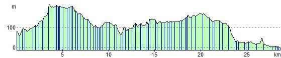
Elevation Profile