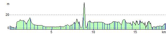
Swansea to Port Talbot
12.4 miles (20 km)
![]()
![]() Follow National Cycle Route 4 on this easy ride along the South Wales coast.
Follow National Cycle Route 4 on this easy ride along the South Wales coast.
You start by the marina in Swansea and head east through the docks towards the village of Briton Ferry. The ride then heads to the Port Talbot sea front where you can enjoy a lovely traffic free section along the prom. The final stretch takes you along the River Avan to the finish point at Port Talbot railway station.
Swansea to Port Talbot Ordnance Survey Map  - view and print off detailed OS map
Swansea to Port Talbot Open Street Map  - view and print off detailed map
Swansea to Port Talbot OS Map  - Mobile GPS OS Map with Location tracking
Swansea to Port Talbot Open Street Map  - Mobile GPS Map with Location tracking
Cycle Routes and Walking Routes Nearby
Elevation Profile