Swindon to Cirencester
18.6 miles (30 km)
![]()
![]() This route follows National Cycle Route 45 from Wiltshire to Gloucestershire taking you through a lovely part of the Cotswolds. The route starts in Swindon Old Town and follows an off road cycle path into the countryside. A dismantled railway line takes you to Cricklade before more off road paths take you through Cotswold Water Park - the UK's largest water park with 133 numbered lakes.
This route follows National Cycle Route 45 from Wiltshire to Gloucestershire taking you through a lovely part of the Cotswolds. The route starts in Swindon Old Town and follows an off road cycle path into the countryside. A dismantled railway line takes you to Cricklade before more off road paths take you through Cotswold Water Park - the UK's largest water park with 133 numbered lakes.
An on road section then takes you into the finish point in Cirencester near the abbey grounds.
To continue your cycling around Swindon see our circular Swindon Cycle Route which visits several of the parks in the town.
Swindon to Cirencester Ordnance Survey Map  - view and print off detailed OS map
Swindon to Cirencester Open Street Map  - view and print off detailed map
Swindon to Cirencester OS Map  - Mobile GPS OS Map with Location tracking
Swindon to Cirencester Open Street Map  - Mobile GPS Map with Location tracking
Cycle Routes and Walking Routes Nearby
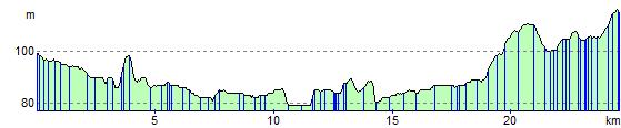
Elevation Profile