Totnes to Ivybridge
19 miles (30 km)

 Follow National Cycle Route 2 through Dartmoor National Park from Totnes to Ivybridge.
The route starts nears the River Dart in Totnes passing Totnes Weir before heading through the pretty village of Dartington and into the Devon countryside on off road paths. There is then a long on road stretch through the beautiful Dartmoor National Park taking you to Ivybridge on the River Erme. You finish near the tourist information centre in Ivybridge.
Totnes to Ivybridge Ordnance Survey Map  - view and print off detailed OS map
Totnes to Ivybridge Open Street Map  - view and print off detailed map
Totnes to Ivybridge OS Map  - Mobile GPS OS Map with Location tracking
Totnes to Ivybridge Open Street Map  - Mobile GPS Map with Location tracking
Cycle Routes and Walking Routes Nearby
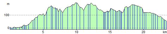
Elevation Profile