Waskerley Way
![]()
![]() This is a shared cycling and walking path that follows the route of the old Stanhope and Tyne Railway line.
This is a shared cycling and walking path that follows the route of the old Stanhope and Tyne Railway line.
The path starts near Consett and runs to Weather Hill passing through woodland and open moorland. You will also pass the delightful Smiddy Shaw Reservoir, Hisehope Reservoir, Waskerley Reservoir and Tunstall Reservoir near the village of Wolsingham.
Postcode
DH8 9DY - Please note: Postcode may be approximate for some rural locationsWaskerley Way Ordnance Survey Map  - view and print off detailed OS map
Waskerley Way Open Street Map  - view and print off detailed map
Waskerley Way OS Map  - Mobile GPS OS Map with Location tracking
Waskerley Way Open Street Map  - Mobile GPS Map with Location tracking
Pubs/Cafes
On the route you could refuel at the old Parkhead Station. They have some nice tea rooms here where you can enjoy a good range of refreshments. There's also secure cycle storage for your bikes. You can find them towards the end of the route near Stanhope at Parkhead Station House, DL13 2ES.
Nana B's Teas is located just to the east of Smiddy Shaw Reservoir and the old Waskerley Station. They serve a good range of meals and snacks in lovely surroundings. You can find them at postcode DH8 9HR just over a mile east of the reservoir. They are dog friendly with a water bowl available.
Further Information and Other Local Ideas
The trail passes just to the north of Tunstall Reservoir near Wolsingham. The pretty nature reserve is worth a small detour from the route if you have time.
At Lydgate the path coincides with the Consett and Sunderland Railway Path and the Lanchester Valley Walk. These long distance trails can make a nice extension to your outing.
To the north of the path you'll find one of the county's highlights at Pow Hill Country Park and Derwent Reservoir.
Cycle Routes and Walking Routes Nearby
Photos

This disused railway - the Stanhope and Tyne Railway was built to serve the needs of the Weardale lead and iron ore mining industries in the 19th century; the section in the photo is part of the nearly level summit section at 400 metres, the highest section of standard gauge railway in Britain. In the trees in the distance is Waskerley village.

A group of cyclists on the trail in the summer of 2004. The railway reached an altitude of 509m (1670ft), and was the highest standard-gauge railway in Britain.

The Waskerley Way by Hown's Farm. Straight on for the old railway path, right for the bunkhouse.

Cyclists on mountain bikes on Muggleswick Moor.

NCN 7 signpost at Lydgate. Where the Waskerley Way, the Consett and Sunderland Path, the Derwent Valley Path and the Lanchester Path meet.

Heather moorland beside the path
_-_geograph.org.uk_-_297729.jpg)
Waskerley Reservoir (north-east corner). The reservoir is popular with birdwatchers

A car park on the the Way, a bridleway on the line of an old mineral railway.
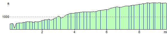
Elevation Profile