Whitehaven to Sunderland
![]()
![]() This is the complete C2C National Cycle route crossing the country from east to west along a number of cycle tracks/paths and minor roads. You will see some spectacular scenery as you pass through the Cumbrian Lake District and Northumberland before the last leg through County Durham and the finish point at Roker Pier on the east coast of England at Sunderland.
This is the complete C2C National Cycle route crossing the country from east to west along a number of cycle tracks/paths and minor roads. You will see some spectacular scenery as you pass through the Cumbrian Lake District and Northumberland before the last leg through County Durham and the finish point at Roker Pier on the east coast of England at Sunderland.
See the Whitehaven to Tynemouth page for the other section.
Click here for a comprehensive guide to this popular route.
Scroll down for a route video and the full gpx file.
Whitehaven to Sunderland Ordnance Survey Map  - view and print off detailed OS map
Whitehaven to Sunderland Open Street Map  - view and print off detailed map
Whitehaven to Sunderland OS Map  - Mobile GPS OS Map with Location tracking
Whitehaven to Sunderland Open Street Map  - Mobile GPS Map with Location tracking
Further Information and Other Local Ideas
The Reivers Route links with this trail. The popular coast to coast ride crosses the country from Whitehaven to Tynemouth. The signed trail runs mostly along National Cycle Route 10.
Cycle Routes and Walking Routes Nearby
Photos

C2C route at Sunderland

Consett and Sunderland Railway Path. The Consett and Sunderland railway path is a component of the C2C cycle route, and carries large numbers of recreational cyclists throughout the year. This section runs between Lydgett Junction and the Consett By-pass

Monument on Coast to Coast Cycleway in Consett

Sea-to-Sea route marker, Whitehaven. A view looking northwest to the marker post for the start (or end) of the Sustrans Sea-to-Sea (c2c) cycle route at the Waterfront, Whitehaven, with the Wave, and the Crowsnest, on Lime Tongue in the background. It is traditional for cyclists (and walkers) to dip their boots in the water here before setting off on the crossing to Sunderland.

One of the Beamish shorthorns. Built by Sally Matthews, the Beamish Shorthorns, constructed from scrap metal contentedly graze by the side of the Consett and Sunderland railway path

Dead Friar's Stone. This Part Of the C2C follows the line of the old Weatherhill and Rookhope Railway

Dropping down to the River Wear. Stadium of Light (Sunderland Football Club) in the background

The Lambton Worm. This sinuous earthwork, designed by Andy Goldsworthy, commemorates the local mythical beast "the Lambton Worm". This feature lies on the Consett and Sunderland Railway Path
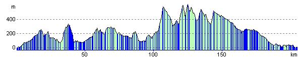
Elevation Profile