Beacon Way - Sandwell to Chasewater Canals and Country Walk
15.5 miles (25 km)
![]()
![]() This is the section of the Beacon Way from Sandwell to Chasewater, taking in the nature reserves, canals and woodland around Walsall.
This is the section of the Beacon Way from Sandwell to Chasewater, taking in the nature reserves, canals and woodland around Walsall.
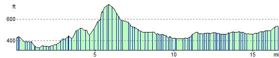
You start by the restored, Victorian Sandwell Park Farm in West Bromwich and head through the lovely Sandwell Valley Country Park. You continue past Rushall Junction and onto Barr Beacon where there are splendid views of the surrounding countryside. Pleasant waterside sections along the Rushall Canal and Wyrley and Essington Canal lead you to the finish point at Chasewater Country Park.
Here there's a beautiful lake, and the heritage Chasewater Railway.
Beacon Way Ordnance Survey Map  - view and print off detailed OS map
Beacon Way Open Street Map  - view and print off detailed map
*New* - Walks and Cycle Routes Near Me Map - Waymarked Routes and Mountain Bike Trails>>
Beacon Way OS Map  - Mobile GPS OS Map with Location tracking
Beacon Way Open Street Map  - Mobile GPS Map with Location tracking
Cycle Routes and Walking Routes Nearby
Photos

Forge Mill Lake, Sandwell Valley Country Park

Chasewater Pier
Elevation Profile