Bembridge Trail - Newport to Bembridge Isle of Wight Walk
![]()
![]() This trail runs from Newport to Bembridge via the lovely village of Brading. Highlights include splendid views of Arreton and Brading Downs and a pleasant stretch along the River Yar.
This trail runs from Newport to Bembridge via the lovely village of Brading. Highlights include splendid views of Arreton and Brading Downs and a pleasant stretch along the River Yar.
There's also the historic Bembridge Fort and the photogenic Bembridge Windmill to see on the way.
The trail finishes at the attractive Bembridge Harbour.
To continue your walking you could pick up the Isle of Wight Coast Path in Bembridge and head north to Ryde. See the Ryde to Bembridge Coastal Walk for more details.
Bembridge Trail Ordnance Survey Map  - view and print off detailed OS map
Bembridge Trail Open Street Map  - view and print off detailed map
*New* - Walks and Cycle Routes Near Me Map - Waymarked Routes and Mountain Bike Trails>>
Bembridge Trail OS Map  - Mobile GPS OS Map with Location tracking
Bembridge Trail Open Street Map  - Mobile GPS Map with Location tracking
Further Information and Other Local Ideas
On the north western outskirts of Newport you'll find the expansive Parkhurst Forest. The forest is criss crossed with miles of good walking and cycling trails and a fine place to extend your outing. It's also great for wildlife spotting with the resident red squirrels of particular note.
In August you can try the popular St Helens Fort Walk in the neighbouring village which lies just to the north. The walk takes you out to the 19th century St Helens Fort along the causeway at low tide.
Just west of Ryde there's another historic highlight at Quarr Abbey. The Grade I listed abbey monastery dates back to the 12th century and includes a scenic estate with lovely gardens, wildflower meadows and woodland with red squirrels to look out for. Very near the abbey there's also some peaceful woodland trails at Firestone Copse and the splendid Isle of Wight Heritage Steam Railway centre at Havenstreet.
For more walking ideas in the area see the Isle of Wight Walks page.
Cycle Routes and Walking Routes Nearby
Photos

View from Bembridge Trail. Having climbed the steep hill out of Shide, this stunning view awaits you.
The chalk grasslands along the trail are home to wildflowers like common rock-rose, cowslips, and orchids, which thrive in the calcareous soils of the area.
In woodland sections, oak, ash, and beech trees dominate, while mosses and ferns thrive in shaded and damp areas.
Marshy areas near the River Yar host wetland plants, such as reeds and sedges, creating an ideal environment for wetland species.

On the trail at St George's Down. In the distance is Chillerton Down, with its radio mast just visible.
Birdwatchers may spot herons, egrets, and ducks in the marshlands, while woodland birds like woodpeckers, robins, and warblers are common in forested areas.
The Isle of Wight is also home to the rare Glanville fritillary butterfly, often seen fluttering near the trail in warmer months.
Mammals include red squirrels, which benefit from the absence of grey squirrels on the island, and bats that roost in wooded areas

Bembridge Windmill. From the footpath to the west near Mill Farm. This path is part of the Bembridge and River Yar Trail.
The windmill is a remarkable historical structure and the last surviving windmill on the island. Built around 1700, it remained operational throughout the Victorian era until its closure in 1913. Managed by the National Trust, it has been carefully preserved, retaining most of its original milling machinery. Visitors can explore its four floors to learn about the grain-to-flour process and enjoy panoramic views from the top. A short film on the ground floor provides additional insights into its history and operation.
The windmill has also inspired artists, including J.M.W. Turner, who painted it during his travels. Its picturesque surroundings are ideal for picnics and walking, with the Culver Trail offering scenic routes nearby. Educational activities and family-friendly events are held throughout the year, making it a popular destination for both learning and leisure

Trail on St. George's Down. The trail looks attractive and manages to avoid the worst of the quarrying as it is squeezed between a haul road and various worked out pits, now settling lagoons. This is looking east, the path having come up from Newport.

High Street, Brading

Newport

The beach at Bembridge

Bembridge Fort. Built 1862-1867 against a possible invasion of Napoleon's forces. It had 3 officers and 100 men. It had 2 4" breech loading and 6 muzzle loading guns.
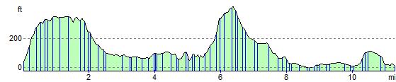
Elevation Profile