Isle of Wight Coast Path
![]()
![]() Explore the stunning coastline of this beautiful island on this circular walk.
Explore the stunning coastline of this beautiful island on this circular walk.
The walk begins at Cowes and passes the lovely Gurnard and Thorness Bays before coming to Newtown, with its delightful wildlife Nature Reserve. You continue along the Newtown River estuary, passing Newtown Bay on your way to the popular town of Yarmouth where the ferry arrives from Lymington. Here you will cross the river Yar and pass the castle before coming to the village of Freshwater.
The path then leads you to the south west tip of the island where you will pass the beautiful Alum Bay and the famous Needles rocks. The Needles park is one of the most popular attractions on the island and includes a chairlift which gives fabulous views of the Needles Rocks and Lighthouse. There's also the old National Trust owned batteries to see here.
From the Needles you head east towards St Catherine's point, passing Tennyson Down, Freshwater, Brighstone and Chale Bay.
After rounding St Catherine's point (the southernmost point of the island) and lighthouse you pass a series of pretty bays and coves on your way to the popular seaside resort at Ventnor.
The path then visits two more lovely seaside resorts at Shanklin and Sandown. Shanklin has a picturesque old town and a pretty esplanade with a number of hotels and restaurants. Sandown Bay is also attractive with a popular stretch of golden sand and the interesting Victorian town to explore.
You then round the chalk down at Culver Down and Bembridge Fort, before passing Bembridge village with its pretty harbour, bays and beaches. Next stop is the seaside resort at Ryde with beaches and the esplanade to enjoy.
The final section takes you from Ryde to Cowes, crossing Wooton creek and passing Osborne House.
The house was built between 1845 and 1851 for Queen Victoria and Prince Albert as a summer home and boasts stunning gardens, state rooms and galleries.
Soon after you cross the river Medina and arrive at the finish point at Cowes harbour.
Please click here for more information
Isle of Wight Coast Path Ordnance Survey Map  - view and print off detailed OS map
Isle of Wight Coast Path Open Street Map  - view and print off detailed map
Isle of Wight Coast Path OS Map  - Mobile GPS OS Map with Location tracking
Isle of Wight Coast Path Open Street Map  - Mobile GPS Map with Location tracking
Pubs/Cafes
At the western end of the route you will find the old batteries next to the Needles. Here there's a nice National Trust tea room which is a great place to stop off for some refreshments. The tea room is in an attractive vintage style transporting you back to the 1940s. There's excellent views over the area as the tea-room is located in the Port War Signal Station that was specifically built to give the clearest, closest views of shipping in the Solent and around the Needles.
Dog Walking
Most of the path is great for a dog walk and the Old Batteries tea room mentioned above has a dog friendly seating area.
Further Information and Other Local Ideas
On the southern side of the island you could take a small detour to visit Brighstone Forest and the National Trust's Mottistone Manor. Here you'll find beautiful gardens and bluebell woods in the grounds surrounding this historic Elizabethan manor house.
In August you can try the popular St Helens Fort Walk on the eastern part of the island, near Ryde. The walk takes you out to the 19th century St Helens Fort along the causeway at low tide. Just west of Ryde there's another historic highlight at Quarr Abbey. The Grade I listed abbey monastery dates back to the 12th century and includes a scenic estate with lovely gardens, wildflower meadows and woodland with red squirrels to look out for.
For more walking ideas on the island see the Isle of Wight Walks page.
Cycle Routes and Walking Routes Nearby
Photos

Isle of Wight Coastal Path at Brighstone Bay

Coast path on West High Down. Tennyson Down and the associated monument in the distance. The famous poet used to live at nearby Farringford House. The chalk hill of Tennyson Down was part of the Farringford Estate and Tennyson would walk this hill daily. His son subsequently left the downland to the National Trust. In 1897 a Celtic cross was erected to Tennyson's memory. The inscription on the far side reads:
"IN MEMORY OF ALFRED LORD TENNYSON THIS CROSS IS RAISED A BEACON TO SAILORS BY THE PEOPLE OF FRESHWATER & OTHER FRIENDS IN ENGLAND AND AMERICA"
It is situated on the highest point of the downs, nearly 150 metres above sea level.

Cowes Marina

Freshwater Bay. Looking along the beach from the terrace of the Albion Hotel. The bay sits at the western end of the region known as the Back of the Wight or the West Wight which is a popular tourist area. It is banked by some impressive steep chalk cliffs. The village is also noteworthy as the birthplace of physicist Robert Hooke who, using a microscope, was the first to visualize a microorganism. It is also notable as the home of Poet Laureate Alfred Lord Tennyson. He was the Poet Laureate during much of Queen Victoria's reign and wrote the famous poem "The Charge of the Light Brigade".

Yarmouth Castle. This artillery fort was built by Henry VIII in 1547 to protect Yarmouth Harbour from the threat of French attack. These days it's a lovely spot to enjoy a picnic and enjoy fine views across the Solent.

Alum Bay. Looking across Alum Bay to Alum Chine. The bay is near the westernmost point of the Isle of Wight, England, within close sight of the Needles rock formation. The area is part of the Needles Marine Conservation Zone and the shore and heath above are part of the Headon Warren and West High Down Site of Special Scientific Interest

The Needles. Looking out from the Old Battery across the searchlight emplacement to The Needles. This row of three stacks of chalk rise about 30m out of the sea off the western extremity of the island. The Needles Lighthouse stands at the western end of the formation and was built in 1859. These unusual stacks were featured on the BBC Two TV programme Seven Natural Wonders (2005) as one of the wonders of Southern England. They take their name from a fourth needle-shaped pillar called Lot's Wife, which collapsed in a storm in 1764. Although the remaining three stacks do not resemble a needle the name has stuck.

Sandown Pier. Sandown has an easily accessible, sandy shoreline with beaches that run continuously from the cliffs at Battery Gardens in the south to Yaverland in the north. Sandown Bay is home to one of the longest unbroken beaches in the British Isles.
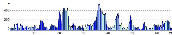
Elevation Profile