Bewerley Industrial Heritage Trail
![]()
![]() Explore the Pateley Bridge area of Nidderdale, North Yorkshire on this historical circular walk. The trail explores nearly a thousand years of lead mining history while also offering splendid views of the beautiful Nidderdale area.
Explore the Pateley Bridge area of Nidderdale, North Yorkshire on this historical circular walk. The trail explores nearly a thousand years of lead mining history while also offering splendid views of the beautiful Nidderdale area.
Highlights include the delightful waterfalls at Throstle Nest
and Coldstones Cut - a huge artisitic construction which visitors can freely walk through and explore. The sculpture overlooks the working Coldstones Quarry and offers fabulous views of the scenery of Nidderdale in the Yorkshire Dales.
Bewerley Industrial Heritage Trail Ordnance Survey Map  - view and print off detailed OS map
Bewerley Industrial Heritage Trail Open Street Map  - view and print off detailed map
Bewerley Industrial Heritage Trail OS Map  - Mobile GPS OS Map with Location tracking
Bewerley Industrial Heritage Trail Open Street Map  - Mobile GPS Map with Location tracking
Further Information and Other Local Ideas
Just to the north of Pateley Bridge there's a lovely waterside path around the expansive Gouthwaite Reservoir to try.
For more walking ideas in the area see the Nidderdale Walks page.
Cycle Routes and Walking Routes Nearby
Photos

Bewerley Park Outdoor Education Centre. Bewerley Park is an outdoor education centre belonging to North Yorkshire County Council. School groups from all over the county stay here and take part in rock climbing, canoeing, gorge walking, caving and other outdoor activities. The whole site [which extends into the next square] can be seen from the Panorama Walk across the valley.

Toft Gate lime kilns

Coldstones Cut overlooks the huge working Coldstones Quarry and offers spectacular views.

Coldstones Quarry

Trail at Greenhow Hill. This is the Greenhow Industrial Heritage Trail approaching the B6265 from the south.

Lane descending towards Brandstone Beck. Narrow access lane descending over upland pastures towards the small valley of Brandstone Beck and abandoned lead mine workings and spoilheaps.

Sheep pasture, Ladies Riggs

Weir on Foster Beck. One would guess that the weir was constructed in the 19th century to provide a head of water for the mill race leading to Foster Beck Mill [see photos this square]. More water came along another channel from Brandstone Beck just above its confluence with Foster Beck.
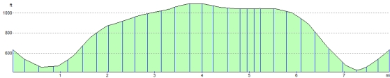
Elevation Profile