Bosley Cloud
![]()
![]() This short circular walk visits the Bosley Cloud hill, near Congleton, on the edge of the Peak District. The hill stands at 343 m (1,125 ft) and offers wonderful views over Congleton, Greater Manchester and the surrounding Peak District hills and countryside.
This short circular walk visits the Bosley Cloud hill, near Congleton, on the edge of the Peak District. The hill stands at 343 m (1,125 ft) and offers wonderful views over Congleton, Greater Manchester and the surrounding Peak District hills and countryside.
You start at the parking area at Timbersbrook and follow the Gritstone Trail to the Cloud summit. You can descend the same way or take an alternative path to the south of the peak. The route follows good waymarked footpaths and includes woodland sections followed by a steep ascent to the craggy sandstone summit. Here you will find a toposcope which details the landmarks you can see from the viewpoint. These include the Dane Valley, the Pennine Hills and the Potteries.
If you would like to extend your walk you could continue along the Gritstone Trail or pick up the Maccelsfield Canal on the Cheshire Ring Canal Walk just to the north.
You could also head to the nearby Bosley Reservoir and pick up the waterside path.
Postcode
CW12 3PP - Please note: Postcode may be approximate for some rural locationsBosley Cloud Ordnance Survey Map  - view and print off detailed OS map
Bosley Cloud Open Street Map  - view and print off detailed map
*New* - Walks and Cycle Routes Near Me Map - Waymarked Routes and Mountain Bike Trails>>
Bosley Cloud OS Map  - Mobile GPS OS Map with Location tracking
Bosley Cloud Open Street Map  - Mobile GPS Map with Location tracking
Dog Walking
After your walk you could reward yourself with refreshments at the Harrington Arms in Bosley. The pub is located on the Leek Road just over a mile north west from the Cloud summit. It has a nice large beer garden to relax in during the warmer months. You can find them at postcode SK11 0PH for your sat navs.
Further Information and Other Local Ideas
The circular Congleton Walk visits the cloud from the nearby town. It starts from the train station and includes waterside stretches along the Macclesfield Canal and Bosley Locks.
A few miles to the north there's the worthy village of Gawsworth to visit. The village includes three noteworthy historic buildings including the 15th century Gawsworth Hall. The house and grounds of the historic Tudor house are well worth exploring.
For more walking ideas in the area see the Cheshire Walks and Peak District Walks pages.
Cycle Routes and Walking Routes Nearby
Photos

View from Bosley Cloud facing Cheshire
The Ordnance Survey triangulation point at the north end of Bosley Cloud

View of the hill from below

The Cloud as seen from a footpath near Pool Bank. The Cloud seems to dominate, almost threaten Congleton. It is the outstanding feature from Mow Cop to the south to Gawsworth Common to the north.

Path up this gritstone Pennine outlier on the Cheshire Staffordshire border.

Timbersbrook at the foot of the hill. Telephone box and post box in the village centre. You can start the walk from here.
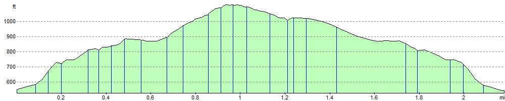
Elevation Profile