Boudicca Way
![]()
![]() Follow the Boudicca Way from Norwich to Diss on this walk through the beautiful, unspoilt South Norfolk landscape. The route runs for about 36 miles with some fascinating historical sites to see on the way.
Follow the Boudicca Way from Norwich to Diss on this walk through the beautiful, unspoilt South Norfolk landscape. The route runs for about 36 miles with some fascinating historical sites to see on the way.
The walk also passes through a series of pretty villages including Shotesham, Saxlingham Nethergate and Pulham Market. There are also views of the rivers Yare and Tas to enjoy and a visit to the Venta Icenorum Roman town at Caistor St Edmund.
The town was the capital of the Iceni tribe, who inhabited the flatlands and marshes of Norfolk and who revolted against Roman rule under their queen Boudicca (or Boadicea) in the winter of 61 CE.
The walk is easily accessible, starting and finishing at mainline railway stations.
Please click here for more information
Boudicca Way Ordnance Survey Map  - view and print off detailed OS map
Boudicca Way Open Street Map  - view and print off detailed map
*New* - Walks and Cycle Routes Near Me Map - Waymarked Routes and Mountain Bike Trails>>
Boudicca Way OS Map  - Mobile GPS OS Map with Location tracking
Boudicca Way Open Street Map  - Mobile GPS Map with Location tracking
Pubs/Cafes
On the route you could stop off at Caistor Hall near Caistor St Edmund. There's the Palm Court Bar and Restaurant located within the main house of the building here. They have a good range of refreshments which you can enjoy in the lovely outdoor area if the weather is fine. The hall also has an interesting history having been built between 1795 and 1797 in the time of King George III by the Dashwood family. You can find the hall at postcode NR14 8QN for your sat navs.
Also on the route in Shotesham there's The Globe to consider. They have a good selection of drinks and a pleasant outdoor seating area. You can find them at postcode NR15 1YG for your sat navs.
At the end of the route in Diss there are a couple of good options. Firstly there's The Waterfront Inn which is in a lovely spot next to Diss Mere. You can sit outside on the balcony and enjoy great views across the water with your meal. The address is 43 Mere Street with postcode IP22 4AG for your sat navs. There's also The Cock Inn on Fair Green. The 500 year old pub does great food and has a nice cosy fire indoors. You can find them at 63 Denmark St, Fair Green with postcode IP22 4BE. They are dog friendly if you have your canine friend with you.
Cycle Routes and Walking Routes Nearby
Photos

Venta Icenorum Roman Fort at the start of the route at Caistor St Edmund near Norwich. View of the ditch along east wall. Before the arrival of the Romans in the area, Norfolk and Suffolk were the home of the Iceni, who in AD 61 rebelled against Roman rule, led by their Queen Boudica.
The revolt was suppressed and the town of Venta Icenorum was established in order to bring stability to the area.

Wild flowers growing on south wall at Caistor St Edmund. As well as the interesting history its a scenic area with views of the River Tas and the surrounding fields.
A variety of wild flowers is growing on the sunny south wall which is covered by soil. The London to Norwich railway line can be seen in the distance. There are two signposted walks, one leading around the Roman defences, the other following the course of the River Tas. Just to the east of the site there is a Early Saxon cemetery, and on raised ground to the north both an Iron Age burial site and Saxon cemetery have been excavated. The Arminghall Henge is located to the north-east.

This section off the path turns off Long Lane leading in northerly direction past Whiteford Farm and emerging on Chandler Road, which it crosses to continue in northerly direction towards the village of Arminghall. The name Boudica (often spelled 'Boadicea', which was the Victorian version or 'Boudicca', used by Tacitus) derives from the Celtic 'bouda' which means victory. Boudica was the wife of the Icenian king Prasutagus. When he died his kingdom was annexed by the Romans, Boudica was flogged and her daughters raped. In AD 60 or 61 Boudica led the Iceni, along with others, in revolt. They destroyed Camulodunum (Colchester) and the site of a temple to the former emperor Claudius. Boudica was defeated in the end and is reported by Tacitus to have poisoned herself. The site where she is buried is unknown.

Footpath marker beside Boudica's Way with a wintery scene in the background. This footpath marker is located at the south-eastern edge of Caistor St Edmund chalk pit which can be seen on the other side of the fence.

To Stoke Holy Cross on the trail. This section of the long distance footpath leads from Shotesham to Stoke Holy Cross, further to the north.

To Lakenham. The path here traverses the Arminghall Henge site - having been carried over a stile on White Horse Road. It leads through this pasture and continues in south-westerly direction towards Old Stow Road.

Arminghall Henge - located close to the start of the route just to the north of the Caistor St Edmund site. Its outline is still visible in low light. In 1929 a prehistoric timber circle and henge monument site was discovered 1˝ miles (2˝ km) northwest of Arminghall village by Gilbert Insall VC who had been taking aerial photographs of the area in search of new archaeological sites. Whilst flying at around 2,000 feet (600 m) he noticed cropmarks of a circular enclosure made of two concentric rings with a horseshoe of eight pit-like markings within it.

Arminghall Henge 2. When discovered the entire site was around 75 m in diameter. The site was visited a week later by O.G.S. Crawford, who pronounced it to be the Norwich Woodhenge but it was not until 1935 that it was first excavated, by Grahame Clark. His work established that two circular rings were ditches, the outer one 1.5 m deep and the inner one 2.3 m deep, with indications of a bank that once stood between them. The pits in the middle were postholes for timbers that would have been almost 1 m in diameter. The site dates to the Neolithic, with a radiocarbon date of 3650-2650 Cal BC (4440±150) from charcoal from a post-pit. The henge is orientated on the mid-winter sunset, which, when viewed from the lication, sets down the slope of nearby high ground, Chapel Hill.
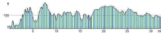
Elevation Profile