Cairn Gorm Walk
![]()
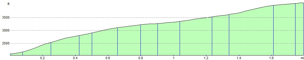
![]() This walk follows the signed 'Windy Ridge Path' from the Cairngorm Ski Centre car park to the summit of the mountain. At 1245 metres (4084 ft) Cairn Gorm is the sixth highest mountain in the United Kingdom. The route passes the Ptarmigan Restaurant, the highest restaurant in the UK. It is located at the Ptarmigan Train Station of the CairnGorm Mountain railway. It's just over half way from the summit so it's a great place to stop for refreshments and enjoy wonderful views of Loch Morlich, the Rothiemurchus Forest, Ben Nevis and Ben Hope. You continue to the summit where you will find a cairn and a weather station building. The views of the surrounding area are truly wonderful.
This walk follows the signed 'Windy Ridge Path' from the Cairngorm Ski Centre car park to the summit of the mountain. At 1245 metres (4084 ft) Cairn Gorm is the sixth highest mountain in the United Kingdom. The route passes the Ptarmigan Restaurant, the highest restaurant in the UK. It is located at the Ptarmigan Train Station of the CairnGorm Mountain railway. It's just over half way from the summit so it's a great place to stop for refreshments and enjoy wonderful views of Loch Morlich, the Rothiemurchus Forest, Ben Nevis and Ben Hope. You continue to the summit where you will find a cairn and a weather station building. The views of the surrounding area are truly wonderful.
You descend via the same path with the option of catching the funicular railway back to the base at Ptarmigan.
The Ben Macdui and Coire an t-Sneachda walks start from the same car park so if you'd like to continue your walking in the area then these are good options.
Postcode
PH22 1RB - Please note: Postcode may be approximate for some rural locationsCairn Gorm Ordnance Survey Map  - view and print off detailed OS map
Cairn Gorm Open Street Map  - view and print off detailed map
Cairn Gorm OS Map  - Mobile GPS OS Map with Location tracking
Cairn Gorm Open Street Map  - Mobile GPS Map with Location tracking
Explore the Area with Google Street View 
Further Information and Other Local Ideas
To the south you can enjoy a circular walk around the beautiful Loch Avon and along the River Avon. There's also the smaller Loch Etchachan, a popular place with wild swimmers and wild campers.
A few miles to the north west there's nice trails around Loch Morlich and the unusual Green Loch in the Glenmore Forest Park. There's good facilities here with a visitor centre and car park.
For more walking ideas in the area see the Cairngorms Walks page.
Cycle Routes and Walking Routes Nearby
Photos

Cairngorm mountains, looking north, taken from the "Windy Ridge Path" to the Cairn Gorm summit, showing cumulus clouds.
The walk traverses a range of habitats, each supporting distinctive flora and fauna. At lower elevations, remnants of Caledonian pine forests feature Scots pine, birch, and juniper, providing habitats for species such as red squirrels and crossbills. As the altitude increases, the landscape transitions to heather moorland, dominated by ling heather and blaeberry, which support insects like the mountain bumblebee. In the alpine zone, hardy plants such as moss campion and dwarf willow adapt to the harsh conditions, and ptarmigans, well-camouflaged birds, can often be spotted among the rocks.

Stacan Dubha

View to the South from the Summit of Cairngorm

Rocky terrain leading to the summit

Ptarmigan Viewpoint

An t-Aonach, the north ridge of Cairngorm. With the path up the ridge in the foreground and views across the Fiacaill a' Choire Chais to Cairn Lochan. Cloud is gathering, and within a couple of hours there will be a blizzard on top.

Cairngorm Ski centre

North East from Cairn Gorm
Elevation Profile